Residents in Austin can expect another dose of scattered showers and thunderstorms this afternoon, a continuance of the wet patterns of late. According to the National Weather Service, there's a 40 percent chance the skies will open after 1 pm today, with temperatures hovering near a balmy 90 degrees and heat index values spiking as high as 100. A gentle east wind may bring some relief, gusting up to 25 mph.
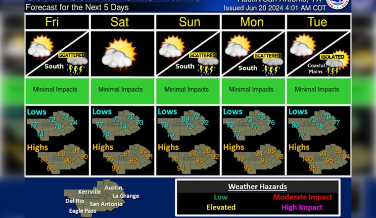
Scattered showers & storms are expected with locally heavy rains possible today. Low chances of showers & storms continue most days with greatest chances across southern areas, especially the Coastal Plains. Below normal temperatures warm to seasonally hot going into next week. pic.twitter.com/lZF4YNGT8O
— NWS Austin/San Antonio (@NWSSanAntonio) June 20, 2024
Tonight, Austin residents might see the tail end of the day's rain with a lingering 30 percent chance of showers before 1 am before conditions clear up, yielding to partly cloudy skies and a mild low of around 74 degrees. The city's weather pattern is under the influence of leftover tropical moisture and daytime heating, creating an ambiance ripe for rainfall, although the dispersion of this precipitation will not be as widespread as Wednesday's deluge and it's reported that no severe weather or flooding is on the horizon, despite the rains, people in Austin will likely see temperatures climb over the coming days, a trend complemented by rising humidity, KXAN notes.
The weekend is set to bring a wave of mostly sunny days and clear nights, with daytime highs of 93 degrees on Friday and Saturday, followed by a bump to a scorching 96 degrees on Sunday, and similarly high temperatures anticipated for the early part of next week, as per the National Weather Service. The nighttime will offer little respite, as lows are forecasted to stay in the mid-70s, stretching up to 78 by Tuesday night. A phenomenon as predictable as the tick of the clock, a calm wind from the east-southeast will become a calming breeze in the evenings.
Nevertheless, as the week comes to a closer the ridge of high pressure that's dominated the eastern sector of the United States is expected to slide westwards over Austin, and later into the vastness of the Desert Southwest, effectively acting as a shield against any tropical storms that might brew in the Gulf, this weather pattern shift is anticipated to result in even higher temperatures next week, potentially reaching up to 98 degrees on Wednesday; KXAN forecasts.


