Chicago residents can expect a mix of sunshine and impending thunderstorms as the National Weather Service in Chicago/Romeoville has forecasted a week marked with variable weather conditions; beginning Monday with sunny skies that could see temperatures soar to a high near 75 degrees, winds will shift from a calm north northwest breeze to an easterly current in the afternoon, as reported by the National Weather Service.
The serene start won't last long, however, thunderstorms are expected to roll in late tonight with a 50 percent chance of showers and thunderstorms, mainly after 1am; these could generate gusty winds, reaching up to 20 mph, and a moderate overnight low around 70 degrees, potential hazards ahead have prompted the NWS Chicago to release a Hazardous Weather Outlook that puts a focus on a "Level 2 of 5 Damaging Wind Risk...up to 60 mph" followed by a "Limited Flooding Risk" that could affect several counties across north central Illinois, northeast Illinois, and northwest Indiana, according to the forecast.
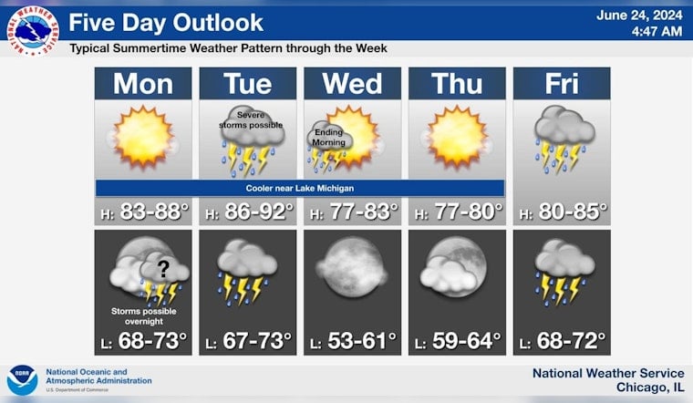
As Chicagoans navigate through the brisk ebb and flow of a typical Midwestern week, the hazardous weather pattern continues into Tuesday with a further 50 percent chance of showers and thunderstorms, which may turn severe and bring with them the risk of damaging wind gusts; these conditions are forecasted to fluctuate throughout the week with Wednesday morning behold a drop in severity, offering mostly sunny skies and a high near 75, come Friday and Saturday, there is yet another bout of thunderstorms expected to sweep through the area with an "Elevated Flooding Risk" and a looming sense of unpredictability in the air, detailed by the five-day outlook provided by the National Weather Service Chicago.
Seasonable summertime weather is expected through the week, with periods of showers and thunderstorms late tonight into early Wednesday morning and again Friday. pic.twitter.com/npzXQnZgGn
— NWS Chicago (@NWSChicago) June 24, 2024
Weekend forecasts suggest a reprieve on the horizon, as Saturday night may clear up to become partly cloudy, with a low around 63, leading into a sunny Sunday boasting a high near 72, in culmination to the oscillating patterns of a weather system trapped in its own unrest, as we look to the skies for respite and hold dear to the fleeting embrace of sunlit days before the next tempest claims the air, as unfolded in this week's climate chronicle.


