The city of Chicago braces as isolated showers and the possibility of thunderstorms make their presence known today, bringing varied weather conditions through the coming days. According to the National Weather Service, the day may see mostly sunny skies post scattered thunderstorms with temperatures peaking near 77 degrees, but conditions will become more uncertain as the week progresses.
Residents looking forward to tranquil nights may find solace tonight, with forecasts indicating mostly clear skies and a low around 63. However, this respite is short-lived, as a high swim risk at Lake Michigan beaches emerges later in the evening, stretching into Thursday morning. This is primarily due to strong onshore winds trailing a cold front that are expected to build waves between three to six feet, as reported by the National Weather Service Chicago.
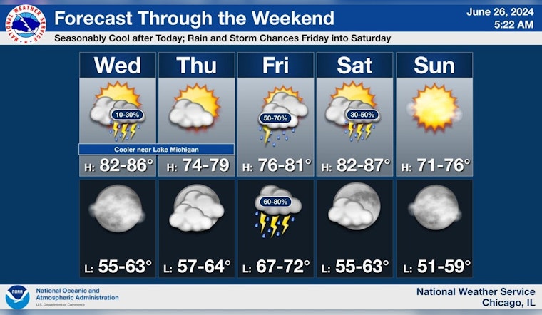
Looking toward the end of the week, Chicago will see sunny weather with a high near 69 on Thursday before the threat of showers and storms re-emerges on Friday. The chance of precipitation jumps to 60% with showers likely and a thunderstorm possible after 1 pm, followed by an 80% chance of steady rainfall into the night. The detailed forecast in Chicago also warns of elevated flooding risks on Friday, indicating a potentially damp start to the weekend for residents and visitors alike.
Marine activity will also be disrupted, with the Hazardous Weather Outlook warning of hazardous conditions for small craft tonight, and again on Sunday and Tuesday. Thunderstorms remain a continued concern, with a limited risk pervading from today through the weekend and into next week. Specific to next Tuesday, the forecast suggests yet another day with the potential for thunderstorms, as summer in Chicago continues its unpredictable dance with the elements.


