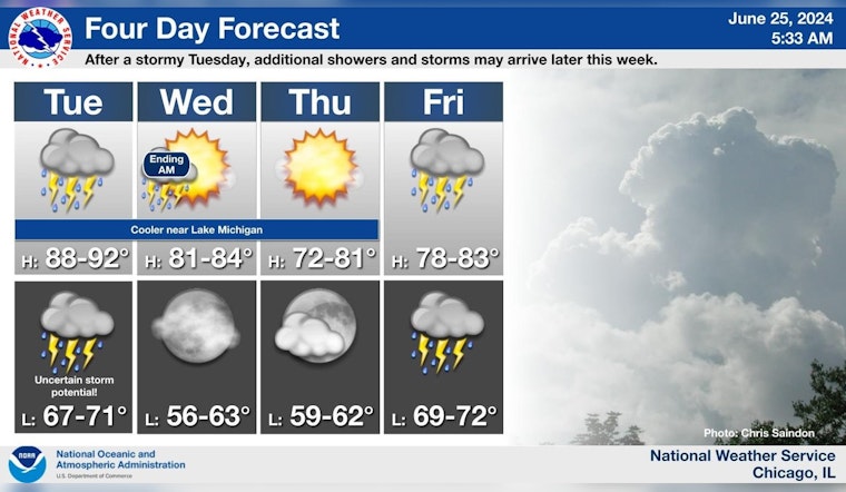
Chicago residents are bracing for a turbulent weather week as multiple storm systems threaten the region with showers, thunderstorms, and potentially severe weather conditions. The National Weather Service's forecast for today anticipates showers and thunderstorms, mainly before 2pm, with a 60% chance of precipitation and a heat index climbing to a stifling 98 degrees. Winds from the west southwest could reach 20 mph, gusting up to 30 mph, potentially compounding the storm-related risks faced by locals and travelers alike, especially small craft navigating the choppy waters of Lake Michigan. Detailed Forecast in Chicago suggests residents can expect a quarter to half an inch of new rainfall today.
The threat level has ramped up, according to the Hazardous Weather Outlook issued this morning, which warns of an "Elevated Thunderstorm Risk" with potential winds up to 70 mph and ping pong ball size hail. Residents particularly in north central Illinois, northeast Illinois, and northwest Indiana are advised to remain vigilant of the "Elevated Flooding Risk" and "Limited Excessive Heat Risk." Spotter activation might be necessary as storm systems move southeast at 40 mph. The Outlook also denotes that the hazardous weather conditions could persist into the weekend with thunderstorm and flooding risks elevated on Friday and limited storm risks through Monday.
Real-time impacts of the weather system are currently unfolding as storms move into the southern Chicago metro and along the I-81 corridor. A glimpse of the approaching trouble was shared by the National Weather Service Chicago on social media, showing a shelf cloud looming before it passed over their Romeoville office earlier today. NWS Chicago's post reads, "Here is a view of the shelf cloud before it rolled across our office here in Romeoville, IL this morning. Storms are now moving into the southern Chicago metro and I-80 corridor."
Here is a view of the shelf cloud before it rolled across our office here in Romeoville, IL this morning. Storms are now moving into the southern Chicago metro and I-80 corridor. #ILwx #INwx pic.twitter.com/Its0Jut3nZ
— NWS Chicago (@NWSChicago) June 25, 2024
As the storms bear down on Chicago, the potential for damage and disruption is clear and residents are encouraged to stay informed and take necessary precautions. The forecast predicts aftereffects may include a brief respite on Wednesday, with a lower 20 percent chance of showers and thunderstorms before 10 am, leading to a mostly sunny day with highs near 76. However, the reprieve may be short-lived as more showers and thunderstorms are in the forecast for Friday, carrying a 60% chance of precipitation. Complicating commutes and outdoor activities, Friday night will likely be wet as well, with continued thunderstorms and a low of around 71 degrees, foreshadowing a weekend that may offer more of the same unpredictable and potentially hazardous conditions.


