Phoenix residents, brace yourselves for an exceptionally hot week ahead. A scorching forecast with today's temperatures soaring to a high near 113 degrees. The gentle winds shifting from calm to a westerly flow at around 5 mph in the afternoon offer little reprieve from the heat. This evening promises a slight drop in heat, with partly cloudy skies and a low hovering around 91 degrees, while the winds turn southerly, maintaining a soft 5 mph pace, as reported by the National Weather Service.
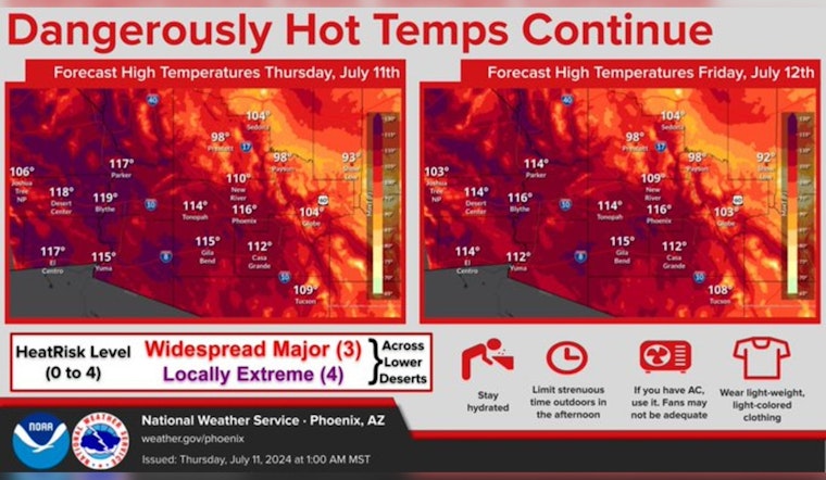
An Excessive Heat Warning remains in effect through tomorrow for the AZ lower deserts and southeastern CA. Afternoon high temperatures will be similar to what we've already seen this week. Keep practicing smart heat safety! #azwx #cawx pic.twitter.com/bKAQWYqAKM
— NWS Phoenix (@NWSPhoenix) July 11, 2024
Looking towards Friday, the thermometer is expected to climb even higher, reaching a near-landmark high of 114 degrees. The day will begin with an east wind that will swing west-southwest in the afternoon around 5 mph. Friday night forecasts suggest a 20 percent chance of showers and thunderstorms before 11 pm, providing a potential, albeit slight, cooling effect for the nighttime when temperatures are predicted to settle around 92 degrees, as per the National Weather Service. The wind, unwavering and westward at 5 to 10 mph, will lighten eventually.
As the weekend hits, 'hot' remains the operative word with Saturday's outlook showing mostly sunny skies and a high again surpassing the 110-degree mark, reaching near 111. A south-southeast wind in the morning will change to west-southwest later in the day, ranging from 5 to 10 mph. Thunderstorm chances make a comeback on Saturday night with a 20 percent chance predicted, though they may only offer minimal relief as temperatures are anticipated to dip to a low of around 89 degrees.
The chance of showers and thunderstorms rises somewhat on Sunday, hitting a 30 percent probability after 11 am under mostly sunny conditions and a high nearing 106 degrees. Sunday evening, those odds hold steady, with thunderstorm activity mainly before 11 pm and clouds collecting to create a mostly cloudy sky. As the mercury falls to a more manageable but still warm low around 87 degrees, the northwest wind will take a turn, heading south-southwest into the evening.
The early week doesn't stray from the pattern established by its sizzling predecessor, with Monday also presenting a 20 percent opportunity for showers amidst mostly sunny conditions. The high is forecasted to hover around 106 degrees, while the low at night is expected to remain unchanged, circling 88 degrees, according to the National Weather Service. A west-southwest wind at 5 to 10 mph ensures the air keeps moving, albeit modestly.
Remaining consistent, Tuesday through Wednesday are anticipated to be mostly sunny days with highs maintaining a stronghold in the triple digits, 107 and 108 degrees respectively. Nighttime conditions on both days will mimic previous evenings, with partly cloudy skies and lows around 88 degrees. Wind patterns will follow familiar trajectories, maintaining a subdued pace from the southwest shifting west in the afternoons.


