The Memphis region braces for inclement weather today as the National Weather Service forecasts heavy rainfall and strong winds, with the potential for significant flooding and power outages. According to the National Weather Service Memphis TN, the area is set to experience "northeast wind 15 to 20 mph, with gusts as high as 40 mph," mandating a Wind Advisory effective from 9 AM this morning until 1 AM CDT Friday. This advisory covers East Arkansas, North Mississippi, Southeast Missouri, and West Tennessee.
Good morning, Mid-South! You can find our latest briefing on Tropical Storm Francine here: https://t.co/7g29FlHUoN
— NWS Memphis (@NWSMemphis) September 12, 2024
Showers are underway across portions of the Mid-South as Francine lifts north. Stay weather aware as portions of the Wind Advisory and Flood Watch may need modified pic.twitter.com/l1jjHROfr1
Residents have been warned of potential dangers driving, especially for high profile vehicles, due to the gusty winds—reportedly strong enough to displace unsecured objects, tear down tree limbs, and interrupt power for some. As instructed, "Gusty winds will blow around unsecured objects. Tree limbs could be blown down and a few power outages may result," as stated by the NWS Wind Advisory.
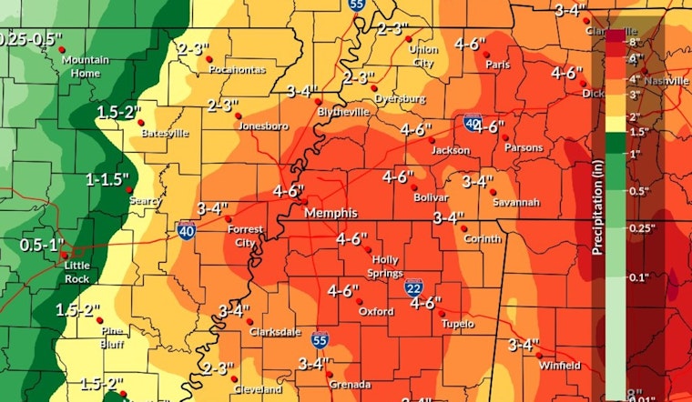
The weather situation has become critical enough that a Flood Watch remains in effect. It will start from 10 AM CDT this morning through this evening. This watch is due to expected excessive rainfall from what will become Tropical Depression Francine, projecting rainfall from "3 to 6 inches over the watch area," with localized higher amounts possible. The alert underscores that urban areas stand at a particular risk of flooding, potentially impacting rivers, creeks, streams, and other flood-prone locales.
Citizens living in affected regions are urged by the National Weather Service to remain vigilant for possible Flood Warnings and to be prepared to take action should flooding develop. With the possibility that "Excessive runoff may result in flooding of rivers, creeks, streams, and other low-lying and flood-prone locations," as per the NWS Flood Watch. Impending storms are anticipated to produce heavy rainfall as part of a broader tumultuous weather period, which includes chances for showers and thunderstorms throughout the weekend.


