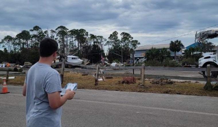
In recent tumultuous weeks, Hurricanes Helene and Milton left a trail of destruction across Southeastern United States, prompting new kinds of first responders to take action. A specialized team from the Department of Energy’s Oak Ridge National Laboratory (ORNL) was quickly deployed, leveraging sophisticated technology to support recovery efforts and gather valuable data for future disaster preparedness strategies. The team engaged in over 100 drone flights that spanned across Florida, North Carolina, and East Tennessee, having collected more than 400 gigabytes of geospatial information primarily concerning energy infrastructure.
Focused on the hard-hit areas, the team, led by ORNL's Andrew Duncan and comprising Zach Ryan, Brandon Stockwell, Jairus Hines, Matt Larson and Jason Richards, used drone technology to aid in their mission. In the aftermath of the hurricanes, with the damage being more extensive than anticipated, Andrew Duncan said, "We set out to collect training data, but the impact went beyond that," in a statement releaesed by ORNL. Local authorities, witnessing the potential of the team’s efforts, reached out and began incorporating the aerial imagery collected by the drones into their recovery operations.
ORNL's proprietary platform, Mapster, was instrumental in sharing the aerial data with emergency responders nearly instantaneously. Duncan explained the profound efficiency of the system, saying, "With Mapster, within 10 minutes of landing the drone, we were able to push the data to ORNL, the Federal Emergency Management Agency and other emergency response partners." This capability starkly contrasted with traditional disaster response tactics which could take significantly longer to translate on-the-ground data into actionable information.
Apart from data collection on the ground, the laboratory's Environment for Analysis of Geo-Located Energy Information, or EAGLE-I, tracked utility outages during the storm's progression. This tool, managed by ORNL since 2016, played a pivotal role in the hands of state and local agencies, as well as federal response units grappling with the storms. On its increased role during the hurricanes, Aaron Myers, who oversees EAGLE-I's development, stated, "EAGLE-I helps us track where the biggest utility outages are, especially in rural areas where smaller counties might not get as much attention."
Looking beyond the immediate crisis, ORNL has set a technology-driven course for disaster response enhancement. Aerial data obtained via drones will train machine learning models to automatically recognize damaged infrastructure, potentially expediting future recovery operations. The laboratory is also working on further advancements to EAGLE-I, aiming to incorporate advanced data analytics and further remote sensing capabilities to speed up decision-making processes in emergency situations.
The Duck Squad, so named for their Drone Unit Camera Kit or "DUCK," reflects back on the challenges and rewards of their deployment. Pouring personal reflection into his work, Duncan said, "It’s one thing to develop these technologies in the lab but being able to apply them in a real disaster environment and see how much they can help — it was incredibly fulfilling." Their mission underscores a dedication not only to innovation but also to real-world application in times when communities need support the most.


