The city of Chicago is gearing up for more snowfall as meteorologists predict additional accumulations over the weekend. According to the National Weather Service, there's a 50 percent chance of snow starting after 11:00 a.m. today with cloudy skies and a high near 34 degrees. Later tonight, snowfall is likely to continue with a 60 percent chance of precipitation, possibly accumulating around an inch.
Conditions are expected to become blustery with gusts reaching up to 30 mph. The forecast, as retrieved from a National Weather Service report, also indicates that Sunday will see snow, mainly before noon, with temperatures around 21 by 5:00 p.m. and wind gusts as high as 35 mph.
In concurrence, ABC7 Chicago meteorologists have issued an AccuWeather Alert for Saturday due to additional snow. "Another 1-2 inches of snow is expected on Saturday night and Sunday morning," Meteorologist Jaisol Martinez said in a statement obtained by ABC7 Chicago. The afternoon could witness a messy mix of rain and snow with temperatures hovering around freezing.
Fog and freezing rain may affect areas near the Wisconsin-Illinois border while light snow is expected to develop around 5:00 p.m. Lake-effect snow showers could occur on Sunday morning, particularly impacting northwest Indiana. "The snow could make roads and other untreated surfaces slick," Martinez warned. He recommends using caution when driving and walking outdoors. Chicago's most significant snowfall of the season earlier this week was followed by snow showers that disrupted Friday's evening commute, as detailed in an ABC7 Chicago report.
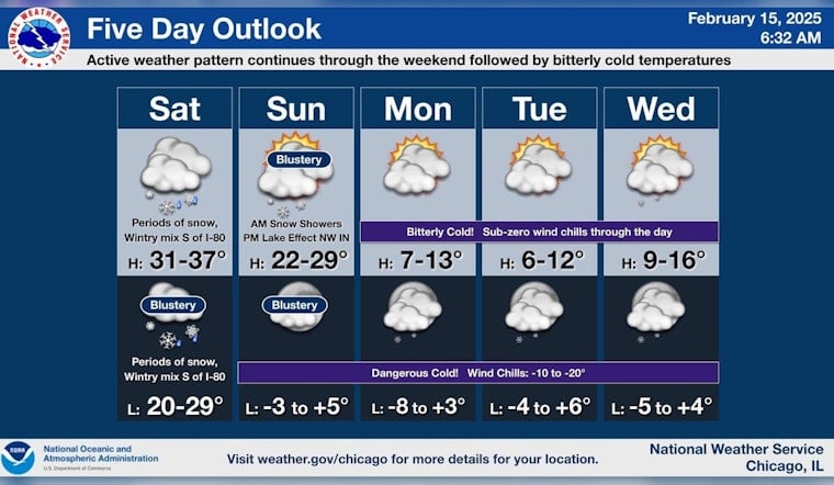
Residents and visitors in the Chicago area should be prepared for changing conditions, with snow likely to affect travel and outdoor activities. This upcoming week appears to remain cold and partly sunny, with low temperatures potentially dropping to around 1 degree on Monday night.


