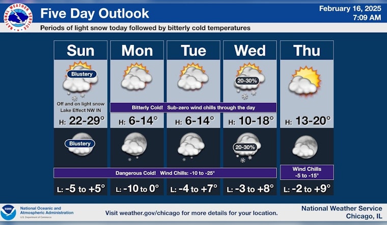
Chicago's weather stays true to its winter reputation as the city anticipates a mix of snowfall and an incoming surge of bitter cold. According to the National Weather Service, today's forecast predicts snow before 11 a.m., followed by periods of flurries, which might accumulate to around an inch. As the temperature peaks near 28 degrees by mid-morning, winds from the northwest reaching 20 to 25 mph, with gusts up to 35 mph, are expected to bring the chill factor back down.
The situation near Lake Michigan is particularly grim, with "some persistent light snow spinning off," resulting in slippery and hazardous road conditions, as reported by FOX 32 Chicago. The lake effect snow, moving to the South Shore later in the day, could result in an additional 1 to 3 inches for Northwest Indiana, potentially reducing visibility and creating slick roads.
The forecast for tonight doesn't promise much reprieve, with mostly cloudy skies and temperatures plummeting to a low of around 3 degrees. Factor in the blustery winds, and the wind chill values could reach as low as -14. The chill is set to deepen further on Washington's Birthday with a high of just 11 degrees and similar wind chill values extending through mid-week, as The National Weather Service reports.
Looking ahead, Chicagoans should brace for winter's icy embrace as sub-zero lows and even harsher wind chills in the -10 to -20 range each morning through about mid-week, as warned by FOX 32 Meteorologist Mark Strehl. The subsequent days will continue the chilly trend with mostly cloudy skies and occasional chances of snow, but also some rays of hope with possible sunny intervals toward the end of the week.


