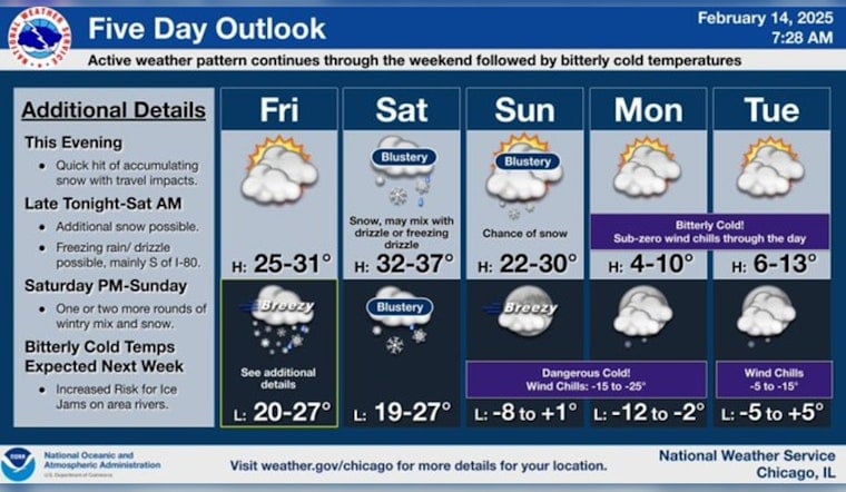
Chicagoans are bracing for a snowy and icy weekend ahead, as the city anticipates a series of winter weather events. According to National Weather Service, there's a 20 percent chance of snow starting after 5 pm today, with steadily dropping wind chill values that could reach as low as -7. Commuters should expect increasing clouds and a high nearly scraping 28 degrees.
As if the sub-zero wind chills weren't enough of a Valentine's Day gift, the city will see a new round of snow moving in around 5 p.m., "potentially snarling streets and roads for evening plans," per the NBC 5 Storm Team. The NWS predicts snow accumulation of 1 to 3 inches tonight and warns of an 80 percent chance of snow before 4 am, possibly mixed with freezing rain. Regarding the upcoming conditions, "The Friday evening commute could be tricky," said NBC 5 Meteorologist Alicia Roman.
The flurry of activity doesn't stop there - Saturday will bring "bursts of snow," especially near and north of I-88 according to the NBC Chicago report. Areas to the south and west should prepare for snow from 2 p.m. onward. With gusty winds, officers warn of sharply reduced visibility and hazardous travel conditions.
Looking a bit further ahead, Sunday's forecast promises snow likely, mainly before noon, taking a blustery turn with northwest winds howling up to 30 mph. However, the temperature is another story – Chicago can expect a high near 29, sinking into downright frigid territory by Monday, a high of just 7 degrees that taunts us, as stated by the NWS.
Stay updated on the latest weather developments and plan for extra commute time over the weekend. Road conditions are expected to be slippery, and visibility may be poor. Take precautions and stay warm as Chicago weathers another bout of its trademark winter weather.


