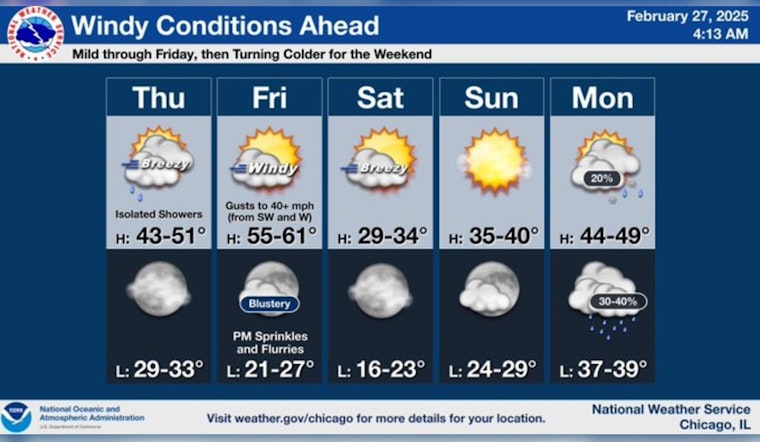
Chicago's anticipation of the weather swing is typical for the city known for its meteorological mood swings. Starting today, the skies hang heavy with clouds and there's a smattering of showers; it's a mostly cloudy day with a teasing 20 percent chance of rain post-9 am, per the National Weather Service. A high near 46 degrees is on the docket, with the potential for the area to see winds increasing in the afternoon, potentially gusting up to 30 mph.
Somewhat warmer temps are promised for the next day, with Friday's forecast from the National Weather Service predicting highs pushing into the mid-50s. But with the temperature's mild climb comes a blustery trade-off: Wind alerts are likely as gusts could whip up to 45 mph. Meanwhile, the onset of the day was shrouded in dense fog until early morning, according to a statement from FOX 32 Chicago, which emphasizes the need for cautious commuting.
As the curtain slowly falls on this week, the weather narrative takes a colder turn. The weekend outlook has Saturday smiling with the sun, though the temperatures hover at a nippy 31 degrees, based on predictions from the National Weather Service. Clear skies continue into the night with lows dipping to around 22. Sunday sustains the sunny streak but only permits the mercury a modest ascent to 36 degrees.
Transitioning into next week, the pendulum swings back towards more clement weather. Monday is set to deliver a high near 46 degrees with a melange of clouds and sunshine. The subsequent days, however, will require vigilant weather watching - the onset of the next system could be a concoction of calamities, "chiefly a rainmaker here Tuesday into Wednesday," as FOX 32 Chicago reports, potentially stirring up thunderstorms or snow. Residents and visitors alike can expect to keep their rain gear at the ready as rain is likely to spatter the early weekdays.


