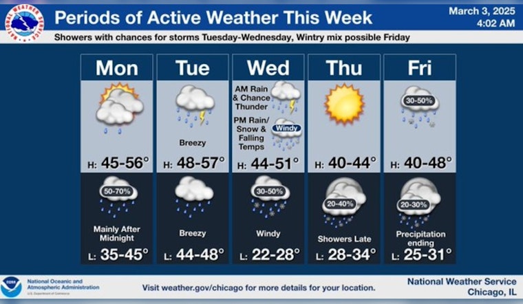
Chicagoans can expect a shift in weather patterns starting today, with cloudy skies and milder temperatures setting the stage for an incoming storm overnight. According to a FOX 32 Chicago report, the city will see temperatures rising into the mid to upper 40s today, with a "mighty close" chance of a light sprinkle.
Heading into the night, a storm system is slated to bring rain to the area, particularly after midnight. While the rain is expected to continue intermittently into tomorrow, temperatures could climb close to 50 degrees. "There is a chance of a rumble of thunder tomorrow," FOX 32 Chicago notes, "but severe thunderstorms are not expected here."
The National Weather Service adds that Tuesday will see showers and a possible thunderstorm, with a high near 48. Gusty conditions will persist as well, with south winds around 15 mph, shifting east southeast in the afternoon, and gusts as high as 25 mph. The chance of precipitation is pegged at 90%, with new precipitation amounts between a quarter and half an inch possible, according to the forecast.
Following the rain, Wednesday's outlook anticipates falling temperatures coupled with windy conditions in the afternoon, leading to a transition from light rain to possible wet snow showers. As the Southeast wind contends with gusts as high as 40 mph, any significant snow accumulation seems unlikely. Thursday will offer a respite with sunny skies and highs in the low 40s; however, the approach of another storm system by Friday suggests a mix of rain and wet snow, with "any minor accumulation of slushy snow" being closely monitored by FOX 32 Chicago.
The weather pendulum is set to swing again. "Signs are pointing to a big, big, big warm-up going into next week," as reported by FOX 32 Chicago, with the warm trend expected to kick off over the weekend. While the short-term forecast suggests a typical mix of early spring unpredictability, it seems Chicago can anticipate a thaw as they move deeper into March.


