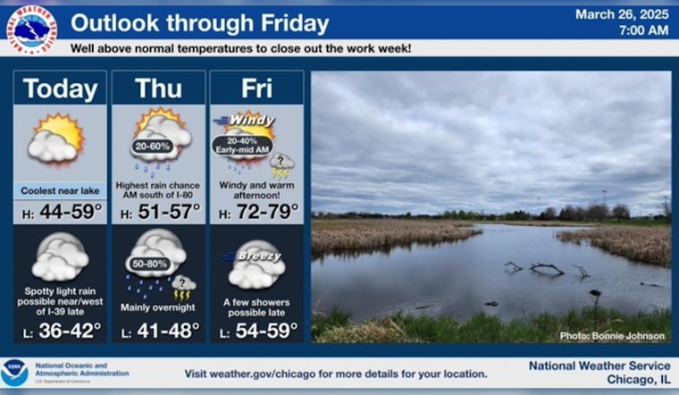
As the city navigates through the final days of March, residents are witnessing a weather pattern that carries a promise of warmth peppered with rainfall uncertainty. According to the National Weather Service, today's Chicago weather should be partly sunny with a noticeable lift in temperatures, reaching a high near 49 degrees. While the city lives its day under a mix of clouds and sun, the lakefront areas may experience a nudge of cooler air.
The real kicker is Friday, when the temperature surge is expected to triumph, rocketing to a high near 76 degrees. However, beneath this warming blanket, "a chance of showers and thunderstorms before 10am, then a slight chance of showers between 10am and 1pm" persists, as noted by the National Weather Service. The southeast wind, turning south-southwest in the afternoon, should amplify, potentially ushering in gusts as robust as 35 mph. But let's not be completely swayed by the spectacle of warmth; the weekend, like an uninvited guest arriving with luggage, could bring showers.
Moving forward into the weekend, a more somber note strikes the forecast. Showers are likely on Saturday, with a hovering cloud of 70% chance of precipitation, and these showers extend into Sunday night, with mild temperatures dropping to the low 40s. As Chicagoans brace for the new week, a symbiotic dance of rain and snow showers on Monday tacks a chill onto sunshine, delivering a high near 41.
While some might clutch their hats over a chilling forecast for Monday, a divergence in longer-range predictions emerges. As reported by FOX 32 Chicago, the U.S. computer model is flagging up to 1.5 inches of precipitation and a possible inch or two of snow come Monday morning. Marching to a different drum, the European model pitches far less rainfall, less than 0.1 of an inch, through Monday, with no snowfall slated for the city. In Chicago's game of meteorological roulette, only the unfolding days can ink over these penciled forecasts.


