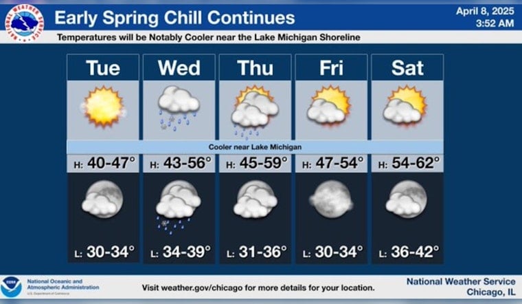
Chicagoans are set to experience a brief interlude of sun today amidst a dance of fluctuating spring temperatures, with highs predicted to hover near a brisk 40 degrees, a north northwest wind shifting easterly as reported by the National Weather Service. Yet as daylight wanes, the city's skies will robe themselves in clouds, heralding a mixed bag of precipitation into the night, including possible rain and snow showers.
According to an article by FOX 32, the rest of Wednesday won't offer any respite as it promises to drench the city with rain, the likelihood of a snowy interjection however slight, highs straining to reach into the low to mid 40s, this comes even as the region braces for gusts that could reach up to 25 mph making for a blustery, bleak midweek scene.
The wet weather is expected to peter out on Thursday, with the day mostly cloaked in cloud cover and temperatures nudging upwards to the upper 40s. It's a slight reprieve as we look towards the end of the week, with Friday projected to be predominantly dry and displaying a gentle ascent into the low 50s under partly sunny skies, inching towards a more amiable atmosphere.
As the weekend unfurls, Chicago is foreseen to bask in a gradual warming trend under partly to mostly sunny conditions, a shift that might pacify the recent chills; Saturday gleaming with forecasted highs in the mid to upper 50s and Sunday uplifting spirits potentially with mid-upper 60s, an optimistic vision of spring amidst the tumultuous ebb and flow of the city's capricious April weather, the warming hues of sunlight will perhaps finally hold sway over the frosty overtures of winter.
Looking ahead to Monday, the city anticipates embracing part-sunlit skies with the mercury expected to soar to near summer-like 74 degrees according to the information culled from the National Weather Service.


