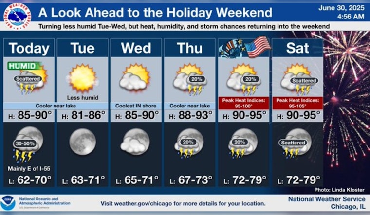
Chicago residents are preparing for a mix of sunny skies and stormy weather, as forecasters predict a fluctuating climate over the next several days. Today, a National Weather Service report indicates a 60 percent chance of showers and possible thunderstorms after 1pm, with a shift from west-southwest wind to northeast as the day progresses, leading to potential new rainfall amounts more significant in thunderstorms.
The inconsistent spell is set to continue overnight, with a 50 percent chance of rain and thunderstorms before clearing to mostly sunny days midweek, temperatures could see highs near 88 and 93 degrees on Independence Day, according to the same National Weather Service report; however with the weekend looming, the chance for showers and thunderstorms makes a return, posing a reminder of the unpredictability of the region's summer.
The storms that may arise could follow the pattern of a severe thunderstorm that already impacted Lake and Cook Counties, where areas in northeast Illinois and parts of northwest Indiana were advised of the potential for damaging winds and heavy downpours. "Not everyone will see it," said NBC 5 Storm Team Meteorologist Alicia Roman, "but remember, if you do, it could be on the gusty side," NBC Chicago reports.
Post-storm calm is expected to make an appearance, with predictions pointing towards less humidity come Tuesday, and the hot and muggy conditions will not return until Thursday's forecast signals temperatures escalating once again, carrying through into the weekend as the city anticipates the Fourth of July celebrations and with any disturbances more "few and far between" the weather could remain friendly for holiday festivities according to the same report; Saturday's forecast hints scattered storms may revisit Chicago skies, sprinkling uncertainty on the otherwise dry holiday outlook.


