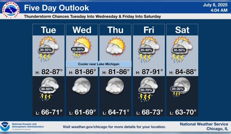
Chicago is bracing for mixed weather patterns this week, as residents can expect a blend of sunshine, scattered showers, and thunderstorms, with temperatures fluctuating in the high 80s and touching upon the 90° mark. According to a National Weather Service forecast, there's a 40% chance of precipitation today with thunderstorms possible after 3 pm, and tonight's forecast includes scattered showers and thunderstorms before clearing up around 4 am, as residents can expect a mostly cloudy sky with lows around 71°.
Wednesday's outlook is slightly more promising with isolated showers, though thunderstorms could still pop up after 1 pm under mostly sunny skies, the high near 80°, and as the week progresses, Chicagoans will see a return to dry conditions on Thursday, paired with sunny skies and a high around 83°. Friday plots a similar course with sunny early hours before a 30 percent chance of afternoon rain and thunderstorms roll in; this heralds in a high near an ambitious 90° mark only to descend into a night where the chance of showers persists.
Continuing this pattern, FOX 32 Chicago reports that yesterday marked a brief respite from the warmth, finishing 1° below the average for July 7, but today the heat surges back with highs brushing against 90° and skies partly sunny, there’s a pronounced opportunity for afternoon rain. Any unsettled weather is expected to dissipate by nightfall, leaving mostly clear skies and a low of around 72°.
The remainder of the week is shaping up to be a blend of warmth and potential wetness, as Thursday is forecasted to remain dry with mid-80s temperatures, while Friday ramps up the heat and humidity, bringing highs around 90° and a tangible chance for late-day showers and thunderstorms, the weekend continues this trend with very warm temperatures maintaining their hold in the upper 80s, not excluding scattered showers and thunderstorms, before arriving at a mostly sunny and similarly warm Sunday.


