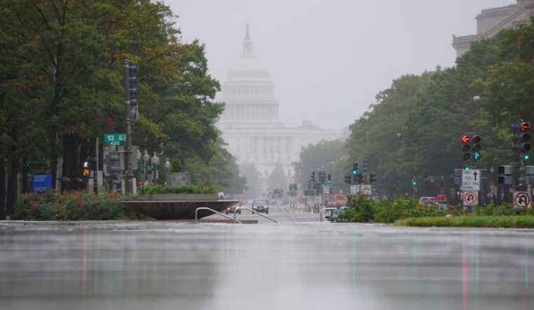
Washington D.C. faces a bout of inclement weather today with an advisory from the National Weather Service (NWS) forecasting a tumultuous mix of showers, thunderstorms, and patchy fog, leading to potential hazardous conditions for area residents. The NWS has issued statements warning of "showers and thunderstorms before 1pm, then scattered showers" between 1 pm and 3 pm with an "east wind 11 to 14 mph becoming southwest in the afternoon," gusting up to 25 mph. According to the detailed forecast, total new rainfall could amount to between a half and three-quarters of an inch.
Coastal Flood Warnings, singularly disruptive, continue for Calvert and Saint Mary's Counties through to the evening for Anne Arundel County. Residents are cautioned that, during these heavy rains, there may be "an isolated instance or two of flooding," particularly this morning. As the Hazardous Weather Outlook specifies, "Special Marine Warnings may be needed on the tidal waters."
Following the tempestuous day, the weather is expected to clear up tonight with forecasts anticipating mostly clear, with a low around 48, and a southwest wind calming down to a breeze of 7 to 10 mph. Looking ahead to Friday and into the weekend, the anticipation of sunny skies with daytime highs reaching near the 60s provides a reprieve from today's storms, with the wind steadying to a consistent westward flow. "Sunny, with a high near 59. Breezy, with a west wind 15 to 22 mph," adds the NWS forecast for Friday, perhaps signalling the end of the turbulent weather pattern for now.
The National Weather Service also highlights a longer-term potential for gusty conditions with "A Gale Watch is in effect for all tidal waters Friday." Citizens nestled along the capital's iconic waterways should heed the Coastal Flood Advisory, which details up to two feet of inundation above ground level in low-lying areas due to tidal flooding. As for the District of Columbia shoreline, the advisory, due to affect areas until 6 PM EDT this evening, warns that "Water is expected to approach parts of the Hains Point Loop Road, but it will likely be closed," leading to possible transportation impediments.
Individuals are urged to approach the conditions with caution and to expect some inundation in flood-prone areas. The NWS concludes, "If travel is required, allow extra time as some roads may be closed. Do not drive around barricades or through water of unknown depth. Take the necessary actions to protect flood-prone property."


