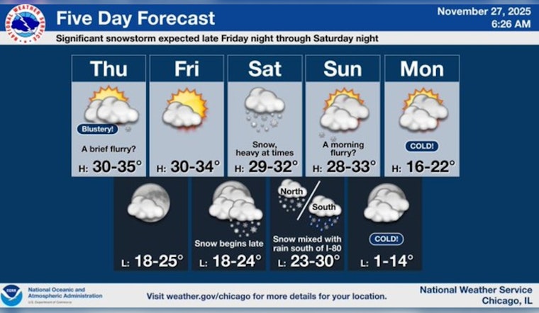
Chicagoans preparing to celebrate Thanksgiving were greeted with a brisk forecast suggesting a slight chance of flurries in the afternoon, according to weather.gov. The high for the day was pegged near a chilly 33 degrees, with a bracing west-northwest wind blowing at 15 to 20 mph and gusts possibly reaching 30 mph. Into the night, the weather was expected to calm somewhat, becoming partly cloudy and dropping to a low of around 24 degrees.
Friday is set to bring a brief respite of mostly sunny skies with the high hovering near 32 degrees. However, Friday night heralds the onset of worsening conditions, as a 40 percent chance of snow looms after midnight. The National Weather Service has issued a Winter Storm Watch effective from 3 a.m. Saturday until 6 a.m. Sunday, warning Chicago residents of the impending snow surge. As documented by ABC7 Chicago, meteorologist Jaisol Martinez forecasts the first flurries to start as early as 3 a.m. or 4 a.m. on Saturday.
Carrying into the weekend, the conditions worsen with the possibility of heavy snowfall during the day on Saturday. Saturday night might also see a transition from snow to rain, complicating the accumulation predictions. The south and southeast wind will increase to 5 to 15 mph, with gusts up to 20 mph, making for a blustery day as temperatures reach a high near 33, as reported by weather.gov.
Differentiating the impact across regions, areas in and around Chicago are looking at receiving four to seven inches of snow while those to the north and west could see more than seven inches. In a statement obtained by ABC7 Chicago, parts of the far south and Indiana might expect two to four inches. Following the passage of the storm, Sunday night might freeze over with lows potentially dropping into the single digits.
As the city weathers the snowy strike, residents will see snow chances continue into Sunday, predominantly before noon with a high again near 33 degrees and mostly cloudy skies. The winter's bite doesn't stop there — plunging into Monday, partly sunny conditions tease a high near 22 degrees before returning to mostly cloudy come nightfall with the low around 11. Looking forward into the week, temperatures appear to remain below freezing, with highs creeping up to the low 30s by Wednesday.


