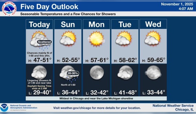
Chicagoans might want to grab their umbrellas before heading out today, as the city braces for scattered showers and slightly cooler temperatures than usual. The National Weather Service forecasts a 20 percent chance of rain this afternoon with highs lingering near the 50-degree mark, a dip from the seasonal average of 56 degrees. Conditions are expected to remain mostly cloudy as winds from the west pick up from 5 to 10 mph.
According to Fox 32, meteorologist Mark Strehl says that the showers we are experiencing today are part of a larger system moving through Wisconsin towards our area. It won't be a continuous deluge, giving room for potential breaks of sunshine despite the prevailing cloudiness; the scattered showers will be straining our skies with their intermittent spritzes. This temporary cooldown comes before a warmer week ahead with temperatures expected to climb, reaching into the lower 60s and inviting more sunshine into the city.
Looking forward to the start of the work week, residents can anticipate a mostly sunny Monday with a high around 59 degrees, as indicated by the National Weather Service's prediction. The west southwest wind will be picking up to 10 to 15 mph, occasionally gusting as high as 20 mph.
As we move past the weekend, the forecast turns considerably drier with mostly sunny skies persisting through Tuesday and Wednesday. Temperatures will hover near the 60-degree mark, creating a gentle reprieve from the chill as we march deeper into autumn. The wind, however, will continue its presence, maintaining a subtle choreography of fallen leaves along Chicago's storied boulevards. Fox 32's experts expect virtually uninterrupted dry conditions to dominate much of the upcoming work week, offering a respite from the weekend's scattered showers.


