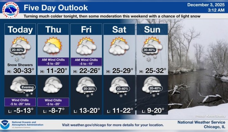
As Chicagoans prepare for a frigid couple of days ahead, weather forecasts indicate an Arctic blast bringing temperatures that could edge near zero. According to the National Weather Service, today's high might approach a chilly 32 degrees amidst a 40 percent chance of snow, which is expected to calm before 3 p.m. NWS reports a chance of patchy blowing snow before 9 a.m., due to winds switching from southwest to northwest, potentially gusting as high as 25 mph.
In keeping with the brisk forecast, temperatures tonight will plummet, with FOX 32 Chicago highlighting that although the official lows may hover above zero within the city limits, wind chill values are set to make it feel like it's more than 10 degrees below. The NWS corroborates this, noting a low around 7 degrees and similarly harsh wind chill values.
Thursday ushers in a semblance of relief through sunshine, which arguably might offer the only comfort against the persisting cold with a high forecasted near a mere 18 degrees. The NWS specifies that despite the sun, wind chill values could drop to as low as -6 degrees. To compound the frosty outlook, winds will shift again, with a gentle 5 to 10 mph breeze transitioning from northwest to southwest as the day progresses, capable of gusting up to 15 mph.
Heading into the weekend, the mercury struggles to claw much higher, with daytime peaks hovering in the upper 20s, as reported by FOX 32 Chicago. Chances of snow loom over the weekend of Friday through to Sunday, though no significant snowstorms are expected to disturb the Windy City. Adhering to the cold trend, the NWS foresees a 30 percent probability of snow Friday evening before the sky mostly clears, only for snow possibilities to creep back into the picture under mostly cloudy nighttime skies on Saturday and Sunday.
Chicagoans enduring this bitter spell have a glimmer of warmth on the horizon. The cold snap is projected to be brief, and by the middle of next week, there's a possibility that temperatures could inch their way above the freezing mark, perhaps by a few degrees, as per FOX 32 Chicago's outlook. Yet even with these slight rises, NWS forecasts maintain that early next week will continue to show chances of snow and mostly cloudy conditions, with daytime highs mostly clinging to the low 30s.


