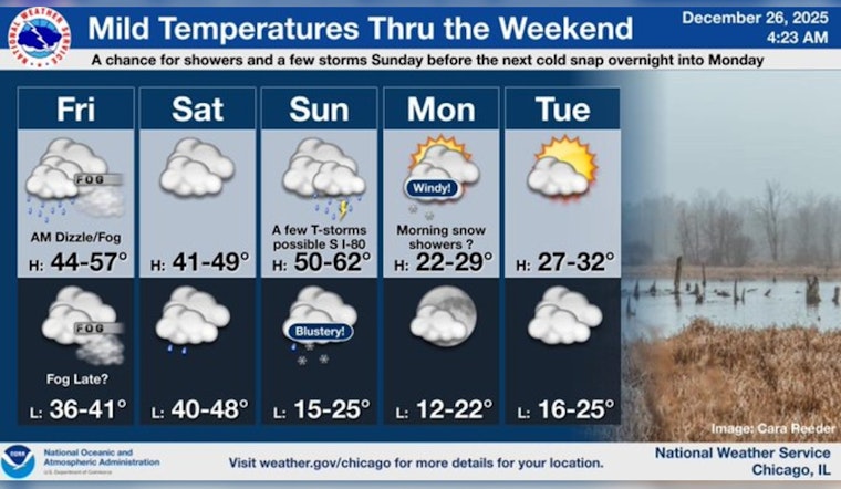
Chicago's weather patterns have the city bracing for a rollercoaster of conditions, with dense fog, sporadic showers, and a significant temperature drop all in the forecast. The National Weather Service has issued a dense fog advisory for multiple counties, including DeKalb, Kane, LaSalle, Kendall, Grundy, Will, and Kankakee in Illinois, as well as Newton County in Indiana. This advisory is slated to remain in effect until 9 a.m., with visibility dropping below a quarter mile in some areas, particularly north of I-80, as NBC Chicago reported.
Travelers during the post-Christmas rush encountered challenging conditions due to the reduced visibility, especially along I-294 at Balmoral, where fog and rain obscured the morning commute. According to the same NBC Chicago report, "If on the road this morning, slow down and be alert for sudden visibility changes." Moving into the weekend, the gloomy weather is expected to persist, with more fog predicted to develop into Saturday morning.
The city's mild temperatures, reaching a high near 48 today with spotty showers possible on Saturday, offer a reprieve from winter's chill. However, NBC Chicago meteorologist Iisha Scott has advised not getting accustomed to the mild conditions. A substantial temperature drop is on the horizon for Monday, when highs are expected to linger around a frosty 24 degrees. There is also a chance of snow showers on Monday morning, with the likelihood of further snow as New Year's Eve approaches.
Looking ahead to the rest of the week, weather forecasts indicate mostly cloudy conditions with temperatures in the 20s and 30s. Residents might experience snow showers before midnight, with a low of around 13 degrees on Wednesday night. The chill is set to continue with a high near 23 degrees on New Year's Day, potentially affecting those celebrating the new year.


