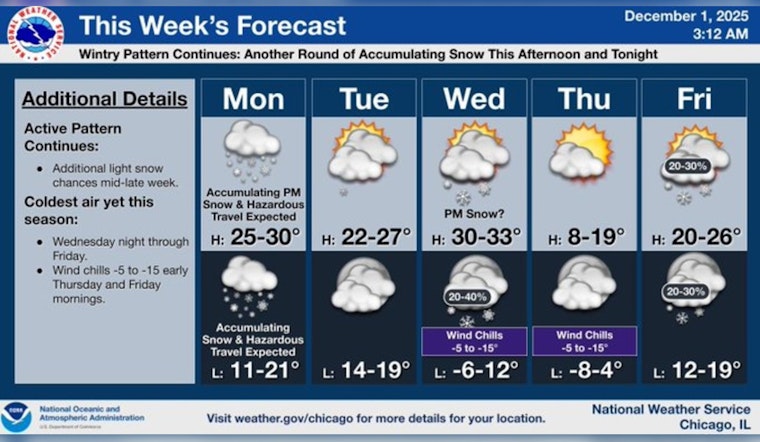
As Chicago braces for more winter weather, residents are advised to have their snow gear at the ready. The National Weather Service reports snow is expected, mainly after 3 pm today, with accumulations of around an inch possible during the daytime. The calm wind is expected to gradually become south around 5 mph in the afternoon. Then, as temperatures drop tonight to about 20 degrees, an additional 1 to 3 inches of snow may blanket the city before midnight.
The anticipated snowfall is set to heavily impact the afternoon commute. According to a FOX 32 Chicago report, "A Winter Weather Advisory will be in effect for all of Chicagoland between 2 p.m. and midnight." This advisory comes with the expectation that the snowfall could get even heavier, particularly in the southern counties. Chicagoans are therefore advised to remain cautious, especially during travel in the affected hours.
Looking beyond today, the National Weather Service forecasts partly sunny skies for Tuesday, with a chill in the air as highs linger around 26 degrees. Wednesday's conditions could see a 50 percent chance of snow after noon and winds gusting as high as 20 mph. As the week progresses, temperatures are not expected to climb much higher, with Thursday’s high predicted at a frigid 18 degrees and Friday hardly warmer at 25 degrees.
Further light snow showers might be showing up intermittently throughout the week with "minimal chances of accumulating snow," per a statement obtained by FOX 32 Chicago. The long-term outlook suggests that it is unlikely for temperatures to rise above the freezing mark, and if it were to happen, it would only be for a fleeting few hours. Adding historical context, last month's snowfall total of 10.4 inches was noted as the "7th-most snowfall on record for the month," amplifying the gravity of the present weather scenario facing Chicago.


