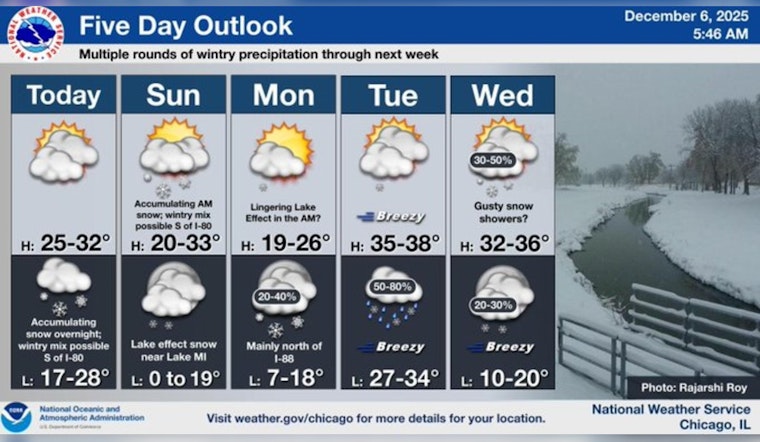
Chicago braces for a wintry mix as snowfall may hit with enough ferocity to disrupt the Sunday morning calm. According to the National Weather Service, a slight chance of flurries post-noon today and snow predominantly after midnight heralds the onset of a chilly week ahead. The temperature will hover around the high 20s, inching progressively lower as the week unfurls. With wind chill, gusts could peak at 15 mph, challenging city dwellers to layer up.
Watch out, travelers: the incoming snowfall, expected between 1 and 3 inches, sets up potentially hazardous travel conditions come Sunday morning. The city's winter warriors will need to navigate slick, snow-covered roads. In a statement obtained by ABC7 Chicago, AccuWeather Meteorologist Jaisol Martinez warns of snow starting between midnight and 2 a.m. Sunday, tapering off by 9 a.m. The swift-changing conditions prompted the issuance of an AccuWeather Alert for Sunday morning hours.
Furthermore, the areas around Cook, Boone, DeKalb, and others are placed under a Winter Weather Advisory from the wee hours of midnight through to 9 a.m. Sunday. With an occasional outlier forecast for some western counties, where an isolated 4 inches of snow could manifest, anticipation for a brisk dose of winter sets in. ABC7 meteorologists caution, these circumstances are likely to set light, sporadic snow showers sprinkling across the cityscape.
Talking temperatures and transitions, the city should see a rise near 30 degrees by mid Sunday morning before conceding to colder inclinations. As per the National Weather Service, a mixture of precipitation is expected into next week with rain and snow likely on Wednesday, while a successive chance for snow sneaks into Thursday's outlook. The city's salt trucks and plows wait in the wings, prepared for the frosty embrace that inevitably accompanies Chicago's December days.


