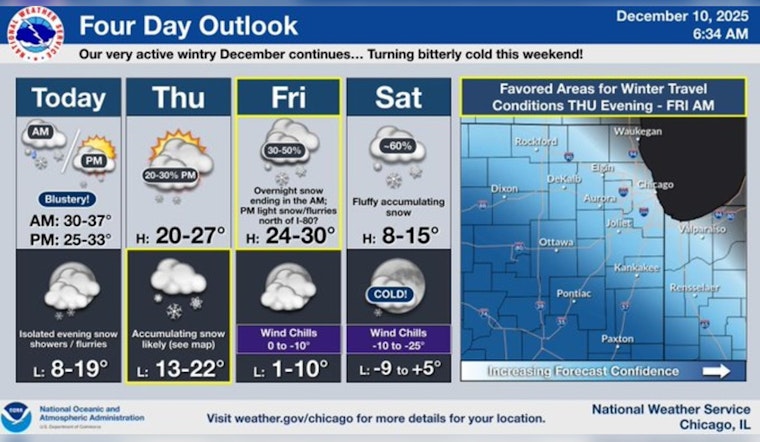
Chicago braces for a mix of snow and wind, which could lead to a challenging commute on Wednesday morning. According to the ABC7 Accuweather Meteorologist Tracy Butler, snowfall is expected to begin between 7 a.m. and 10 a.m., with less than an inch of accumulation. Despite the modest snowfall, "strong winds will make travel conditions messy," Butler explained.
Butler also mentioned that the snow is anticipated to cease by 1 p.m., but the wind will persist, causing temperatures to drop significantly in the afternoon. This change in weather comes as the temperature is forecasted to fall to around 27 degrees by 5 p.m. today, creating freezing and breezy conditions – complete with north northwest winds blowing at 15 to 25 mph, accompanied by gusts as high as 40 mph, according to the National Weather Service.
Looking ahead, Thursday is expected to be cold with temperatures hovering in the mid-20s, setting the stage for a clipper system that may bring additional snowfall Thursday night into Friday morning. The National Weather Service predicts a partly sunny Thursday, but with a 60% chance of snow in the evening, and prospective new snow accumulation of 1 to 2 inches.
The weekend forecast intensifies with "several inches of snow possible Saturday," Butler noted, and bitterly cold expected to follow on both Saturday and Sunday. The likelihood of snow on Saturday is pegged at 60%, with temperatures potentially plunging to a mere 13 degrees. It's a stark reminder that wintry conditions can disrupt not just the warmth, but also the rhythm of urban life.


