Chicagoans can finally experience a small respite from the persistent chill that has gripped the city for weeks. According to FOX32 Chicago, nineteen of the last 20 days have seen temperatures dip below the seasonal average. However, forecasts suggest a gentle shift is upon us—with today's highs edging towards freezing point, offering a brief thaw.
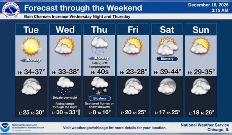
The National Weather Service provides a glimpse of this weather change, revealing that today's skies will remain mostly sunny with highs hovering around 36 degrees. Later tonight, however, Chicago is expected to see increasing clouds with temperatures holding steady near 34 degrees. Moving into Wednesday, the city is poised to maintain mostly sunny conditions and similar high temperatures. It appears relief from the cold is beginning, albeit transiently.
As the week progresses, a developing storm system is expected to bring rain by Thursday morning. This will be accompanied by a surge in temperature, rising to the mid-to-upper 40s before a sudden temperature plummet occurs later that day. According to the National Weather Service, precipitation is expected to cease by Thursday night, but not before the introduction of bracingly cold air, which will drop overnight lows into the teens.
Following the brief weather disturbance, Friday is set to shine mostly sunny, yet with high temperatures lingering near 27 degrees—a one-day snap of colder air. The weekend, however, should be more agreeable, featuring highs in the low 40s on Saturday and upper 30s on Sunday. In an early forecast for the approaching Christmas week, the mercury could ascend to the 50s, promising a warmer-than-average holiday warmth for the Windy City.


