Hawaii slipped through the 2025 hurricane season with far less damage than it could have seen. Tropical systems spun up in the Central Pacific, but none scored a major landfall on the main islands. The impacts most residents noticed were more cosmetic than catastrophic: elevated surf, pockets of heavier rain and only limited statewide damage from wind or flooding, as per Weather.com.
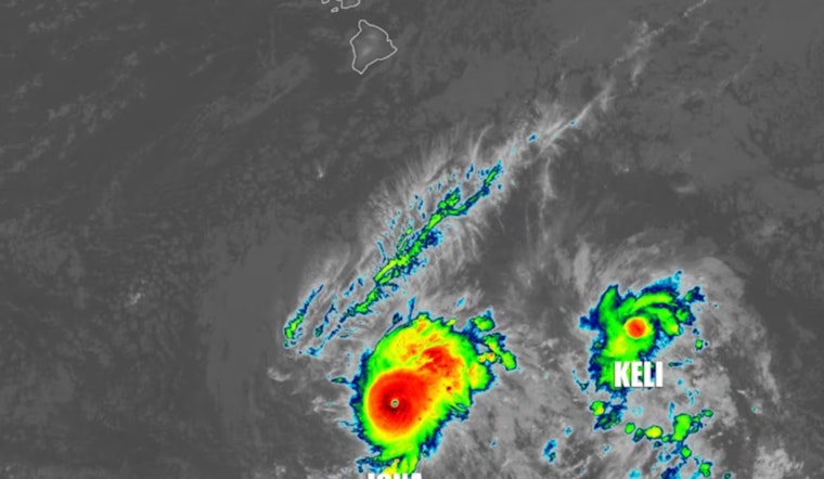
The Central Pacific produced four tropical cyclones this year: Hurricane Iona, Tropical Storm Keli, Tropical Storm Henriette and Hurricane Kiko, a modest total for the basin, according to Weather.com. That tally lands right around the long term average of four to five systems. Before the season even started, NOAA had called for a relatively quiet year, projecting one to four cyclones in its May outlook, as reported by Local 10.
Kiko skirted the islands and sent hazardous surf
Hurricane Kiko was the storm that made islanders pay closest attention. It was the strongest cyclone of the season, and its center tracked close enough to the island chain to push warning level surf onto east facing shores and to squeeze out extra rain over windward Kauaʻi and Oʻahu, according to local meteorologist Kevin Kodama at Mauka Showers. Earlier in the summer, Tropical Storm Henriette passed well to the northeast and likely made dry conditions worse in parts of the state by disrupting the trade winds. Hilo Airport logged unusually low August rainfall during the Aug. 9–11 stretch, Mauka Showers notes. The National Weather Service in Honolulu warned of advisory and warning level surf and issued surf zone forecasts that highlighted elevated conditions along several east facing beaches, according to NWS Honolulu.
Dry summer left local records and concerns
While the islands dodged the worst of the wind and surf, parts of the Big Island spent the summer and early fall on the opposite end of the spectrum: very dry. Forecasters and local observers pointed to stretched water supplies and stressed vegetation in some windward areas. The storms may have stayed offshore, but their indirect effects, including cut off trades, altered surf patterns and lopsided rainfall, kept drought concerns on the table for much of the season, as noted by local observers and weather bloggers.
Why the season stayed relatively calm
Large scale climate patterns lined up in favor of a quieter season. The Central Pacific typically sees about four to five tropical cyclones in a year, and NOAA’s May outlook had already flagged the odds for a below average season of roughly one to four systems, according to Local 10. Climatologists later confirmed a weak La Niña in October, a setup that often suppresses cyclone formation in this part of the Pacific. That shift, and the seasonal dynamics around it, were detailed in coverage by the Honolulu Star‑Advertiser.
What residents should keep in mind
Even in a "quiet" year, the hazards were real. Rip currents, dangerous surf and isolated heavy showers still created local problems as each system passed by. County emergency managers and the National Weather Service continue to press the message that residents and visitors should keep basic emergency kits ready and follow local advisories whenever significant surf or heavy rain is in the forecast, as reported by Big Island Now and NWS Honolulu.
In the end, meteorologists say 2025 will likely be remembered as a low drama season that still carried some pointed reminders. The Central Pacific can deliver a near normal storm count without a direct hit, yet still generate localized trouble, and it only takes one well aimed system to flip a "quiet" year into a costly one.


