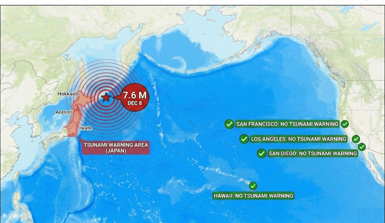
A powerful 7.6 magnitude earthquake that struck off the coast of northern Japan late Monday night prompted immediate tsunami assessments for Hawaii and the U.S. West Coast, with officials quickly confirming that no tsunami danger exists for California, Hawaii, or other Pacific U.S. territories despite the quake generating warnings along Japan's northeastern coastline for waves potentially reaching 10 feet in height.
The earthquake, which hit at 11:15 p.m. local time Monday (9:15 a.m. EST) near Aomori Prefecture at a depth of approximately 32 miles, represents the latest in a series of significant seismic events to impact the Pacific Ring of Fire this year. According to San Francisco Chronicle, the U.S. National Oceanic and Atmospheric Administration issued an alert stating there was "no tsunami danger for the U.S. West Coast, British Columbia, or Alaska" based on earthquake information and historic tsunami records, while according to KITV, the Oahu Department of Emergency Management confirmed no tsunami threat to Hawaii.
Japanese Communities Face Immediate Impact
The situation in Japan remains serious, with several people injured at a hotel in Hachinohe City, where according to Newsweek a hotel worker reported "several injured people" requiring ambulances. The earthquake's violent shaking was described by residents as lasting up to three minutes, with one Aomori City resident reporting his television fell over and cracked from the prolonged tremors.
Japanese authorities issued tsunami warnings for the prefectures of Hokkaido, Aomori and Iwate, with the Japan Meteorological Agency warning of waves up to three meters in size when they reach the coast, as reported by NBC News. Nuclear power officials immediately began conducting safety checks at facilities in the region, with Newsweek reporting no abnormalities detected at the Fukushima, Higashidori, or Onagawa nuclear plants, a critical concern given Japan's history with earthquake-triggered nuclear disasters.
The earthquake occurred in a region that has experienced devastating tsunamis before. According to Wikipedia, major earthquakes and tsunamis along this boundary occurred in 1833, 1940, 1964, 1983 and 1993, with the most recent major event being the January 2024 Noto Peninsula earthquake that killed 691 people and triggered Japan's first major tsunami warning since 2011.
Comparison to Historic California Earthquakes
While Monday's 7.6 magnitude quake generated significant concern across the Pacific, its scale and impact differ markedly from California's most devastating seismic events. The 1989 Loma Prieta earthquake, which struck the San Francisco Bay Area with a magnitude of 6.9, caused 63 deaths, nearly 3,800 injuries, and an estimated $6 billion in property damage, according to Britannica. Despite being nearly a full magnitude point smaller than the Japanese quake, as reported by Wikipedia, Loma Prieta's proximity to densely populated urban areas resulted in catastrophic damage, including the collapse of a section of the double-deck Nimitz Freeway in Oakland where 42 people died.
The comparison becomes even more stark when considering the 1906 San Francisco earthquake. According to Britannica, that magnitude 7.9 earthquake created devastating fires that burned for several days, with more than 3,000 lives lost and over 80% of San Francisco destroyed. As reported by Wikipedia, the total destruction from the 1906 event saw some 28,000 buildings destroyed with total property value loss estimated at $350 million in 1906 dollars, equivalent to more than $10 billion today.
Recent Seismic Activity Across the Pacific
The Japanese earthquake comes just days after Alaska experienced its own significant seismic event. According to Newsweek, a 7.0 magnitude earthquake struck near Yakutat, Alaska on Saturday, December 6, triggering over a dozen other earthquakes in a 24-hour period. The Alaska quake, centered about 56 miles from Yakutat and roughly 230 miles northwest of Juneau, generated 164 recorded tremors in less than 24 hours, as reported by Newsweek, with no casualties or major damage reported and no tsunami warnings issued.
Alaska's frequent seismic activity stems from its position along the Pacific Ring of Fire, the same tectonic system affecting Japan. The state has been the site of some of the world's most powerful earthquakes, including the 1964 Great Alaska Earthquake measuring magnitude 9.2—the second largest earthquake ever recorded globally. That 1964 event generated a tsunami that devastated Crescent City in Northern California, demonstrating how Pacific earthquakes can impact distant shores.
California's Tsunami Preparedness and Risk
Despite Monday's reassuring assessments, California remains vulnerable to tsunami threats from multiple sources. According to Alert San Diego, the most significant remote tsunami to hit southern California occurred in 1960, when a 9.5 magnitude earthquake off Chile generated 4-foot waves at Santa Monica and Port Hueneme, causing major damage to Los Angeles and Long Beach harbors. More recently, as reported by NBC Los Angeles, the 2011 Japanese earthquake and tsunami caused approximately $100 million in damages along the California coast, with Crescent City bearing much of the impact.
San Diego State University geologist Pat Abbott emphasizes that tsunami risk extends beyond wave height. According to CBS8, Abbott notes that a tsunami is "actually the wall in front of a big sheet of water" that may be miles across and "just doesn't quit" as it pushes inland. Computer modeling has shown that a magnitude 9.1 earthquake off Alaska could generate waves of 6 to 13 feet in Southern California, causing $700 million in damage to small marinas and ports.
Hawaii's Strategic Position
Hawaii's location in the central Pacific makes it particularly susceptible to tsunamis from all directions. The islands have experienced devastating tsunamis throughout history, including the 1946 tsunami from the Aleutian Islands that killed 173 people and prompted the creation of the Pacific Tsunami Warning Center. While Monday's Japanese earthquake poses no threat, Hawaii maintains robust warning systems and evacuation procedures, with residents regularly participating in tsunami drills and awareness campaigns.
The rapid assessment that ruled out tsunami danger for Hawaii and California demonstrates the effectiveness of modern warning systems. Unlike the hours of uncertainty that followed historic earthquakes, today's seismic monitoring networks can quickly determine tsunami potential based on earthquake characteristics, depth, and fault movement patterns.
Looking Forward
As Japan continues to assess damage and treat injuries from Monday's earthquake, the event serves as a reminder of the Pacific's interconnected seismic risks. While California and Hawaii were spared any impact this time, experts stress the importance of maintaining preparedness. According to SF.gov, the U.S. Geological Survey estimates San Francisco has a 72% chance of experiencing an earthquake with a magnitude of 6.7 or greater by 2043, underlining the ongoing need for earthquake and tsunami readiness along the West Coast.
The contrast between Monday's Japanese earthquake generating no Pacific-wide tsunami and historical events that have sent destructive waves across the ocean highlights the complex nature of tsunami generation. Strike-slip earthquakes like those common along California's San Andreas Fault typically don't generate significant tsunamis, while subduction zone events—like those possible off the Pacific Northwest's Cascadia fault—pose the greatest trans-Pacific tsunami risks.


