As Chicago residents savor the last echoes of mild weather today, with temperatures expected to peak at least 50° under partly cloudy skies, a notable change is impending. According to FOX 32 Chicago, "This will be the last very mild day for quite some time." While the day may offer a sprinkle of precipitation, it's likely many will remain dry.
The winds of change, however, are sweeping in overnight with a cold front that will usher in cooler air, thus ending the period of unseasonable warmth. Temperatures at midnight could hover in the upper 30s, setting the tone for the following days. There might be a fleeting snow shower tomorrow, but significant accumulations seem unlikely, the cold front marks the onset of a lake-effect snow scenario targeting regions of northwest Indiana and southwest Michigan, particularly LaPorte and Berrien counties, where travel disruptions are a possibility.
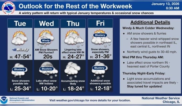
As the week progresses, Chicagoans will experience a notable dip in temperatures. The National Weather Service projects a mostly cloudy Wednesday with temperatures expected to fall to around 22 by 5 pm, and continue to decline into Wednesday night reaching a low of about 16. By Thursday, the forecast promises mostly sunny skies with a high near 26, but snow waits in the wings, likely emerging after midnight and potentially continuing intermittently through Friday and Saturday.
For sports fans braving the cold at the Bears game on Sunday, layered clothing will be essential. Temperatures are forecasted to touch the upper teens, possibly dropping to around 15° by game time, although significant snowfall is not anticipated during the match. The chill lingers into Martin Luther King Jr. Day, with expected highs in the low to mid-20s, a scenario suggesting minimal relief from the bite of wintertime's grasp.


