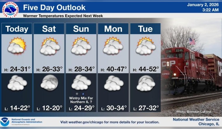
The Windy City is experiencing a flurry of mostly sunny skies tempered by chilling temperatures, as Chicagoans wrap up in layer upon layer against the cold. According to the National Weather Service, today's high will hover near 26 degrees, with a mild northwest wind stirring at about 5 mph, gusts reaching up to 10 mph, as evening approaches, clouds will gather, and temperatures are expected to dip to around 20 degrees.
For those looking ahead, the forthcoming weekend promises marginal temperature ascents, potentially cresting just below the freezing point, with a mostly cloudy Saturday and a high near 29 degrees, the clouds might persist through the night resulting in a low of around 18 degrees, and a mostly sunny Sunday can potentially lead to a high of around 32 degrees, the northwest wind will maintain its presence, flowing at a gentle 5 mph and pivoting southward as Sunday advances.
Looking toward the workweek, the city will see a slow but steady warmup, as reported by FOX 32 Chicago, "a very mild week is on the way with every day Monday through Thursday hitting 40° plus." Football fans attending the Bears game on Sunday may witness nearly ideal conditions, with only a "small chance for a brief wet snow or cold rain shower on Sunday night," ahead of a week where temperatures are set to break the 40-degree mark each day.
In summary, Chicago's current climatic tapestry is one of resilience against the seasonal frost, indeed as Monday approaches with predictions of "Mostly sunny, with a high near 41," residents can anticipate what some may describe as a January thaw, temperatures from Tuesday to Thursday are expected to rise even further reaching highs of 43 degrees, and while a chance of rain is speculated for Thursday, the overarching narrative is that it will be accompanied by the warmest day of the week ending on a near 50-degree high mark indicating a curtain call for the frost's reign, at least for now.


