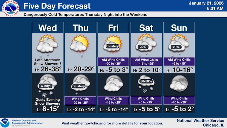
With the mercury dipping and the skies over Chicago churning with winter's resolve, the city anticipates a notable shift in weather patterns this week. As the chance for light snowfalls recedes in the morning hours, a more formidable foe in the form of plummeting temperatures is set to make its presence known. In a report by the National Weather Service, today's outlook spells highs near the freezing mark, with snow showers possibly adding a slight dusting as we head into the evening.
Residents should prepare for a harsh chill tonight, as wind gusts forecasted by the National Weather Service could reach up to 40 mph while temperatures drop into the teens. The cold snap is set to intensify, as explicated further by a FOX 32 Chicago report, which warns of an oncoming polar front slated to usher in the season's coldest air by Thursday night. The prediction includes lows plummeting below zero come Friday morning, with a Friday daytime high struggling to rise above zero despite the presence of sunshine.
Chicagoans must brace for harsh conditions as indicated by the issuance of an Extreme Cold Watch by the National Weather Service, effective from midnight Friday until noon on Saturday, during which wind chill readings could drop to an almost inconceivable minus 35 degrees, as per FOX 32 Chicago. Such predictions underscore the weekend's looming uncertainty and potential perils with Chicago's proximity to a possible snow and ice storm as noted by the European weather model, though this scenario finds no corroboration from its U.S. counterpart just yet.
The upcoming weekend may bring its own set of weather-related challenges, the exact nature of which forecasting models continue to debate, the European model’s predictions, which flag a portion of a devastating snow and ice storm hitting the Chicago area, stand in contrast to the U.S. model's forecasts, these conflicting predictions, as pointed out by FOX 32 Chicago, deserve close monitoring as they evolve and inch closer to reality.


