As Martin Luther King Day sees temperatures plunging in Chicago, residents are experiencing a mix of weather conditions, leading to hazardous travel scenarios. According to the National Weather Service, earlier today saw "scattered snow showers before 10am, then scattered flurries between 10am and noon" with "areas of blowing snow before noon." The wind chill factor brought extreme cold to the area, sinking values as low as -19 degrees, coupled with blustery conditions and gusts up to 35 mph. The National Weather Service shares a cold weather advisory that is in effect until noon, warning of the wind's chilling impact on the city.
The current weather patterns are affecting road safety as well, with FOX 32 Chicago reporting "dangerous travel conditions are likely through at least the early morning hours due to light falling snow." Blowing and drifting snow is contributing to black ice conditions, particularly notable on some southern and western roads. With effective salt being very scarce due to the extreme cold and gusty winds, road conditions are expected to remain treacherous even as the falling snow ceases.
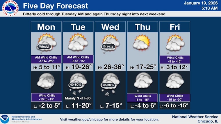
Tonight's outlook suggests only a slight relief with mostly cloudy conditions gradually clearing and temperatures hovering around 4 degrees, as per the NWS. Tuesday offers a brief respite, presenting a mostly sunny day with the promise of highs near 23 degrees. However, the relief will be short-lived, as another round of light snow is poised to hit late Tuesday night into Wednesday, where temperatures might climb to near 31, marking the week's relative warmth.
In the days following, Chicagoans will see a recurring plunge in temperature. FOX 32 Chicago elaborates, projecting a series of colder days with an incoming "blast of frigid Arctic air" for the weekend. Friday's high is expected to be around 10 degrees, with Saturday struggling to reach similar highs. Wind chill values may provoke the issuance of further advisories, and there is the possibility of flurries or light snow during this time.


