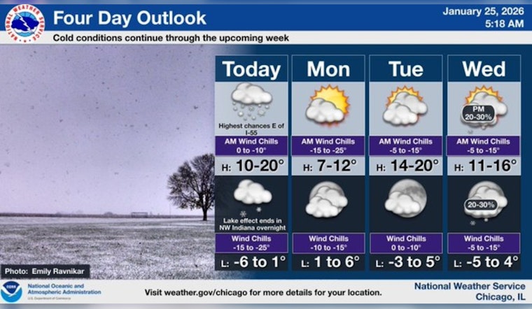
Chicago residents are bracing for more than just a cold front as a massive winter storm sweeps across the region. The city expects substantial snowfall today, with a forecast from the National Weather Service predicting "snow, mainly before 5pm," and "a chance of precipitation is 80%." Commuters are advised to prepare for slick roads and potential delays.
As of early morning, snow accumulation in the area is projected to be between 2 to 4 inches, creating hazardous conditions for drivers and pedestrians alike. Blustery winds compounded the issue, making visibility poor with gusts as high as 25 mph. A 20 percent chance of snow continues into the evening, though the skies are expected to clear up into the night. Temperatures will plummet to around 0 degrees, and the wind chill could make it feel as cold as -17 degrees.
Looking into the new week, Chicagoans are asked to keep their winter gear at hand. According to ABC7 Chicago, Monday will mark the 59th anniversary of the record-breaking 1967 Chicago blizzard, with the upcoming forecast stating "Sunny and cold, with a high near 10." Residents should expect a biting cold with wind chills dipping as low as -18 degrees, which could make outdoor activity hazardous.
A Winter Weather Advisory remains in effect for much of the Chicago area, where "steady and light snowed blanketed from Evanston to Aurora on Sunday," as noted by ABC7. The snowfall interrupted air travel, causing the cancellation of nearly 500 flights at O'Hare and 84 at Midway. Prepared for potential airport closures, the FAA is in the throes of coordinating snow removal and plane deicing efforts with airlines and airports.
The week will continue to be frigid, with the temperature on Tuesday slated to peak at a "high near 18." Wednesday might toss in a fresh curveball with "a 20 percent chance of snow after noon," but it will remain partly sunny. Be ready for Thursday and onward; the days should hold mostly sunny skies, with temperatures gradually inching up into the low 20s by the weekend.


