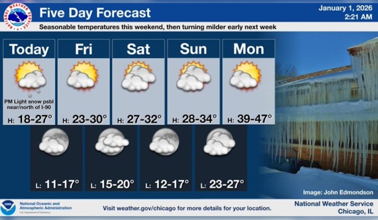
Chicagoans welcomed the New Year under a blanket of cold with some areas experiencing temperatures inching down to single digits. According to FOX32 Chicago, wind chills pushed the feel of the air a notch below zero. Though the day started clear, a disturbance shuffled through around midday, leaving behind a light snowfall, primarily dusting the northern regions of the city.
The remainder of the week's weather appears to be settled, offering Chicago a reprieve from significant precipitation. The forecast, as noted by the National Weather Service, hinted at a "slight chance of snow between noon and 2pm" on New Year's Day, a subtle nod to the midday flurry. With gusts reaching up to 10 mph, and a high nearly scratching at the 22-degree mark, the city is bracing itself for a typically chilled winter's onset.
Transitioning into the evening, the city will see the clouds part somewhat, as mentioned by the National Weather Service, with temperatures expected to hover around 16 degrees. The wind persists with comparable gentleness, stubbornly hanging on to the 5 mph mark.
Looking forward to the weekend, forecasts by both the National Weather Service and FOX32 suggest mostly cloudy skies with highs reaching for 30 degrees, evidence that Chicago's winter grip, while firm, shakes slightly with these small mercies. With the shadows of the workweek stretching into the weekend, Chicagoans will see a gradual climb in temperature, with Monday's high potentially thawing to the 40s.
The week ahead proposes a steady climb in temperature, with Tuesday and Wednesday both boasting the potential for highs in the comfortable low to mid-40 degrees, as "40° is within reach Monday, with low to mid 40s at least on Tuesday and Wednesday," according to FOX32 Chicago. This gentle ascension in warmth offers the city a gradual retreat from the frosty embrace of winter. Yet, the skies remain mostly knit with clouds, withholding the sun's full clarity from the urban canopy.


