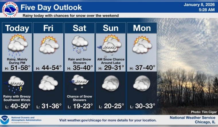
Chicagoans bracing for a rainy encounter today may want to hold off on their hopes for sunny reprieve, as weather forecasts predict a switch-up by the weekend. As reported by the National Weather Service, showers are expected to initiate this afternoon, with a near-certain 90% probability of precipitation. Those showers and thunderstorms are forecasted to continue into the evening hours, potentially bringing a quarter to half an inch of additional rainfall. While the wind gusts may reach heights of up to 30 mph tonight, the day's high will linger around a warm 54 degrees.
As per FOX 32 Chicago's coverage, this bout of weather marks a continuation of the existing pattern, with the city already experiencing its fourth consecutive day with temperatures in the 40s. "Temperatures will continue to climb during this time and will be peaking in the mid to upper 50s tonight, into early tomorrow morning," the outlet noted, highlighting an impending high for Friday as well. Despite early sunshine, the day will see a decline with numbers plummeting to the low 40s.
Citizens will witness the mercury dropping further as we head into the weekend. Saturday's forecast predicts mixed precipitation, an early onset of light rain possibly transitioning to snow as the day progresses. An incoming storm system, as mentioned by the National Weather Service, promises a 70% chance of mixed rain and snow, evolving to all snow post-3 p.m. But not to fear — little to no accumulation is likely due to the temperate high near 39 degrees.
The City of Winds prepares itself for even cooler temperatures on Sunday, with a slight chance of snow before noon, and highs barely making a climb to 31 degrees. However, a slight respite seems on the horizon early next week, as skies clear up to mostly sunny with highs returning to the 38-degree range on Monday. According to FOX 32 Chicago, "Behind the storm on Sunday, highs will be close to freezing," setting the stage for a brisk end to the weekend.


