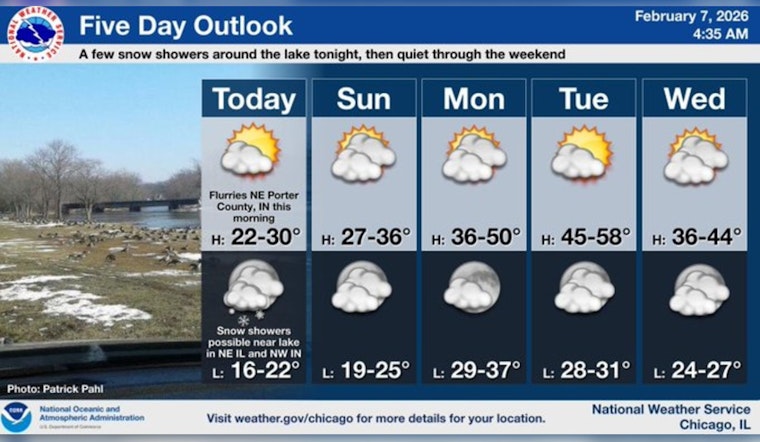
Chicago rolled into Saturday on a deep-freeze setting, with a frigid, mostly clear morning and temperatures stuck in the mid-teens that felt even colder in the wind. Skies should stay mostly sunny through the day with a high near 24, before clouds build in after sunset. Late Saturday night, a weak system may squeeze out a quick burst of snow over far northeast Illinois and northwest Indiana, with a dusting to about a half-inch possible on untreated surfaces. If you are out early or late, think layers and give yourself a little extra time for walking or driving.
Forecast Details
Today’s high should top out near 24, with afternoon readings easing back into the low 20s. Overnight lows are expected to drop into the teens, and wind chills could dip to around 1 degree. North-northwest winds will generally run 5 to 10 mph, with occasional gusts up to about 20 mph.
The main wildcard is tonight. Recent guidance has trended toward a fast, late-night hit of snow mainly over far northeast Illinois and northwest Indiana, with only a dusting to under a half-inch expected where the snow actually reaches the ground. According to the National Weather Service, confidence in how widespread tonight’s snow will be is low, so it is worth checking updated forecasts if you have plans after midnight.
Safety & Local Resources
If the cold is a concern, the city activates warming locations during winter. You can call 3-1-1 to find the nearest site or look up options on the city’s warming-centers map. The Garfield Community Service Center (10 S. Kedzie Ave.) is routinely used for extended warming, and the Englewood Community Service Center (1140 W. 79th St.) is another weekday option.
For people without shelter, the Department of Family & Support Services connects residents with shelter placement and outreach teams. See the City of Chicago warming centers listing for current locations and hours.
Week Ahead
Temperatures are expected to trend milder next week, with highs climbing into the upper 30s on Monday and reaching near 50 by Tuesday, before a cooler and more unsettled pattern edges back in. A weak system could pass south of the area Tuesday night, bringing only a slight chance of showers or a rain and snow mix, followed by another small chance for light snow later in the week.
In short, a brief warm-up is likely early in the workweek, then more typical late-winter ups and downs return. These timing and temperature trends are outlined in the National Weather Service forecast for the Chicago area.


