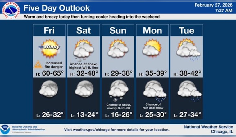
Friday, Feb. 27, started with Chicago under a murky blanket of patchy dense fog in low-lying spots, threatening to bog down the morning commute in a few neighborhoods. Once that lifts, the city gets a taste of early spring, with temperatures climbing toward 61°F and a stiff southwest breeze building through the afternoon.
Dense Fog This Morning
A Dense Fog Advisory is in effect through 9:00 AM CST for parts of the metro, with visibility possibly dropping to one quarter mile or less in spots - conditions that can make driving hazardous. After the fog clears, temperatures are expected to jump into the low 60s while southwest winds increase to 5 to 20 mph, with gusts that could reach 40 mph late in the afternoon. Boaters should also note a Small Craft Advisory for nearshore Lake Michigan waters from 9 AM to 9 PM, according to the National Weather Service Chicago.
Afternoon Winds And Fire Risk
Strong mixing this afternoon is expected to knock humidity down into the mid-20s in some suburbs, creating a brief stretch when dry grass and brush could help a fire spread more quickly. Secure loose patio furniture and skip any open burning. The elevated fire-spread concern is expected to be greatest southwest of the city, and local rules already limit open burning inside Chicago. Forecasters and our earlier preview also point to a quick cool-down for Saturday with a clipper system bringing a chance of light snow, especially north of the city, as highlighted in a spring tease forecast.
Weekend Turn: Chance Of Snow
Saturday will feel very different, with noticeably cooler air, mostly cloudy skies, and a chance of snow after noon. Most locations are expected to see little to no accumulation, although a few spots, mainly north of the city, could pick up under a half-inch. Sunday night brings another chance for light snow with a modest accumulation possible on untreated surfaces, so drivers should be ready for slick patches if they have evening travel plans.


