Fog and mist are draped over Nashville this Thursday morning, with temperatures near 52°F at Nashville International Airport and visibility knocked down in spots. The scattered rain showers that moved through overnight are expected to wind down through the morning, with skies turning partly sunny and a high near 61°F before temperatures slip back into the upper 50s by late afternoon.
Morning Commute and Showers
The messiest part of the day lines up with the morning rush. Showers should taper off from northwest to southwest between roughly 7 a.m. and 10 a.m., so plan on wet roads, standing water in low-lying areas and a few slick bridges. Eastern Middle Tennessee took the brunt of the overnight rain, with many spots picking up 1 to 1.5 inches and a few locations likely closer to 2 inches, while Nashville itself saw lighter totals. According to the National Weather Service, most of the region should dry out by around midday.
Weekend Warmup
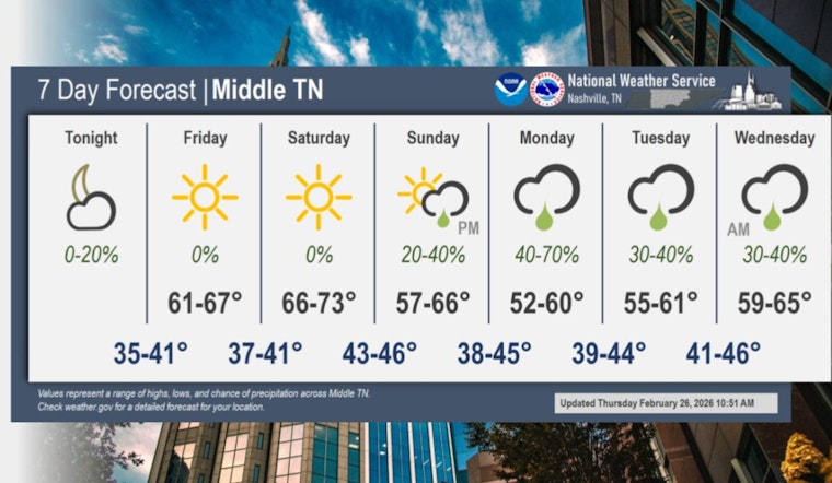
Once the clouds clear, the payoff arrives. Dry, mild weather settles in Friday and sticks around through the weekend, with sunny skies and a high near 66°F Friday, then a warmer Saturday topping out near 72°F before a slight cooldown on Sunday. A front is expected to try to slide back in late Sunday, bringing a chance of showers Sunday night into early next week, as noted by WSMV.
If you have outdoor plans Saturday, that is your best bet: bring sunscreen for the afternoon and a light layer for the evening. For the morning commute, keep an umbrella handy and give yourself a little extra travel time, and check updates from the National Weather Service and local stations if your plans stretch into Sunday and the start of next week.


