Houston woke up to clear skies, a crisp 43°F, and a light north breeze this morning, the kind of chill that disappears once the sun gets to work. Sunshine is expected to bump highs to around 64°F today, with a broader warmup sending readings into the mid-70s by Friday and through the weekend. For most folks, that means a stretch of dry, comfortable days. Out on the water, though, boaters and bay users will still be dealing with stubbornly low tides across Galveston Bay.
Today Through The Weekend
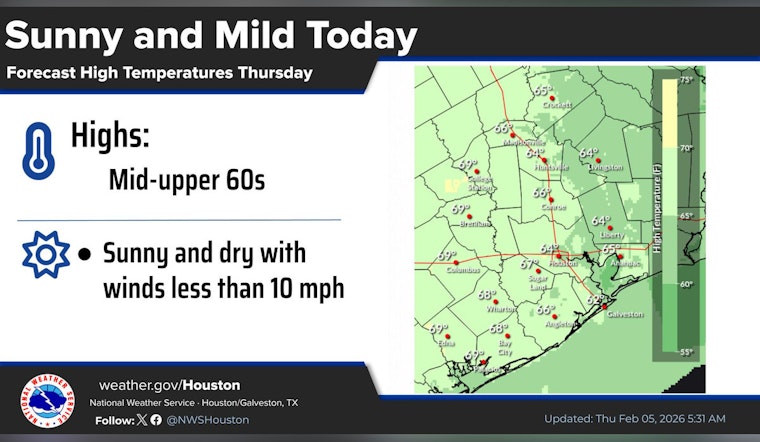
According to the National Weather Service Houston/Galveston office, skies stay mostly clear Thursday with a high near 64°F and a steady warming trend into the 70s by Friday and Saturday. Winds should remain light, generally under 10 mph, and rain chances stay very low through Monday. The next better opportunity for showers or an isolated thunderstorm arrives Tuesday afternoon into Wednesday.
Afternoons will feel noticeably milder than earlier in the week, a decent setup for outdoor plans. Mornings, especially outside the urban core, will still start on the cool side before the sun takes over.
Bay And Boating Notes
A Low Water Advisory remains in effect for the upper reaches of Galveston Bay through noon CST tomorrow, and small-craft operators should note a small-craft caution through 10 AM CST today for certain coastal zones. NOAA observations at Morgans Point show low tides this week dipping near or below mean lower low water. That raises the risk of grounding for shallow-draft vessels, so timing launches for higher tides and checking port notices before heading out is key. Small boats, kayaks and anglers working skinny channels should use extra caution until water levels recover.
Commute And Outdoor Plans
Expect a chilly start in the low 40s across much of the city, with some suburbs dipping into the upper 30s, followed by sunshine by midmorning and pleasantly mild afternoons. It is a solid setup for outdoor errands, a lunchtime walk, or squeezing in a quick park visit.
On the roads, light winds and dry pavement mean minimal weather impact for the evening commute. If you are headed for an early-morning launch on the bay, bring a jacket and double-check tide tables before you back down the ramp.
Looking Ahead
The warming trend keeps rolling into early next week, with most days topping out in the 70s and only isolated rain chances until a better shot at showers or isolated storms on Tuesday into Wednesday. Forecasters emphasize that any storms next week look isolated at this point, and timing could still shift, so it is worth keeping an eye on updates.
For the latest detailed forecast and marine advisories, check in with the National Weather Service and local tide gauges before making on-the-water plans.


