Light freezing drizzle turned parts of the Chicago area into a low-key ice rink on Monday morning, February 2, 2026, slicking up sidewalks and other untreated surfaces as temperatures dipped into the low 20s. Both drivers and pedestrians were urged to watch for spotty icy patches during the morning commute and to move carefully on bridges, ramps, and shaded walkways.
What To Expect Today
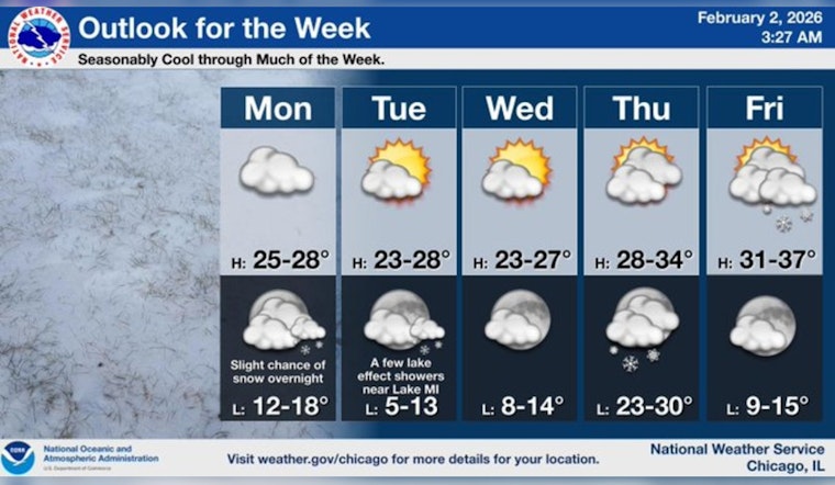
Patchy freezing drizzle is expected to taper off this morning, giving way to isolated snow showers between 11 a.m. and 3 p.m. High temperatures should reach about 29°F before sliding back into the mid-20s this afternoon, with west-southwest winds around 5 to 10 mph and about a 20% chance of precipitation. These timing and temperature details come from the National Weather Service Chicago.
Afternoon Commute Outlook
The National Weather Service noted that untreated sidewalks, parking lots, and inland roads, especially in the northwest suburbs and nearby counties, may remain icy after the early morning drizzle. Expect scattered slippery spots rather than a blanket of snow. Short stretches of black ice on ramps and bridges could catch people off guard, so slowing down, leaving extra space between vehicles, and wearing shoes with decent traction if you are walking are all smart moves.
Looking Ahead
Tonight is expected to be mostly cloudy with a low near 17°F and a slight chance of snow after midnight. Tuesday should bring partly sunny skies with a high near 25°F and gusty north-northwest winds. From Tuesday night into Wednesday there is a small risk of lake-effect snow showers along the Lake Michigan shoreline that could leave a light dusting.
Need A Warm Place?
For those who need a break from the cold, the city activates daytime warming areas and community centers when temperatures fall to freezing and below. The Garfield Community Service Center at 10 S. Kedzie can connect people with shelter and related services. For a current list of warming centers and hours, call 311 or check the WBEZ report.


