Knoxville is waking up to a cold, gray start Friday, February 6, 2026, with temperatures hovering right at freezing around 32°F. Leftover moisture from last night’s chill means slick spots are still lurking, especially on untreated secondary roads, bridges and overpasses during the morning commute. Rain moves in later today, with highs near 48 and a raw west wind on tap.
Afternoon Rain And Gusty Winds
The best shot at rain arrives early this afternoon, mainly between 1 p.m. and 3 p.m. Friday, with roughly a 30% chance of brief showers and a high near 48. Expect west winds 50 mph with gusts as high as 25 mph this afternoon, which could make already wet roads feel even slicker. According to NWS Morristown, valley locations will see the best chance for those afternoon showers before a cold front sweeps through.
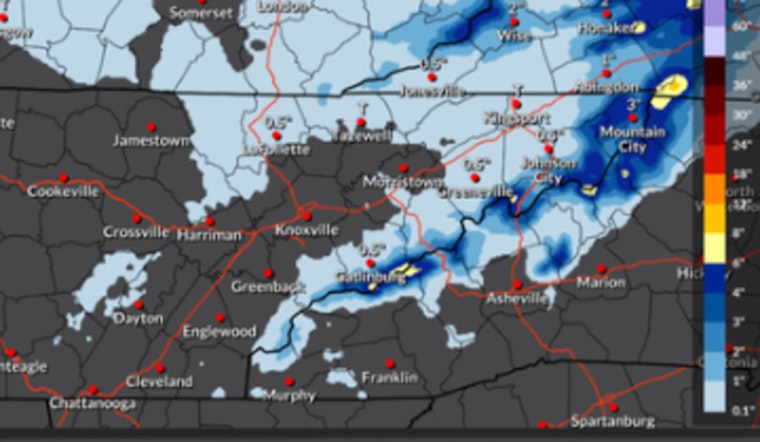
Mountain Snow And Advisories
Higher elevations in the East Tennessee mountains and nearby Southwest Virginia will trade that rain for snow above about 2,500 feet. Those ridge-top spots could pick up around 2 inches from Friday afternoon into Saturday morning, with the highest peaks seeing as much as 6 inches. A Wind Advisory remains in effect for the East Tennessee mountains into Saturday, with gusts up to 45 mph possible, while valley locations can still see gusts near 25 mph Friday evening. Northern valley communities may catch a quick burst of snow or a light dusting as the front slides by, but any accumulation there should stay minor.
Morning Commute And Safety Tips
Watch for black ice on untreated surfaces during the morning commute; residual moisture that freezes into the 20s will keep slick spots possible through at least Friday morning. Drivers are urged to slow down, leave extra stopping distance and give road crews room to work. The Tennessee Department of Transportation also reminds motorists to “take it slow” on bridges and ramps during winter conditions, per local travel guidance. For live road cameras and local updates, call Knoxville 311 or check TDOT and city resources before heading out.
Looking Ahead
Cold air settles in behind the front on Saturday, but sunshine makes a comeback, with highs near 34. After that, Knoxville gets a break from the wintry mix: a notable warm-up arrives early next week, with highs climbing into the upper 50s to low 60s by Monday and Tuesday. With that milder air in place, any precipitation next week is expected to fall as plain rain, cutting down on the chance of wintry impacts after the weekend.


