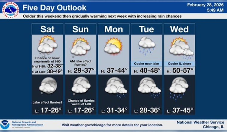
Saturday, February 28, 2026 — Chicago rolled out of bed to a rude reminder that winter is not done yet. After Friday felt like a dress rehearsal for April, early morning readings sat near 35°F at local airports as a narrow band of snow crept into the region. The main window for light snow is roughly 11 a.m. to 5 p.m. today, with most neighborhoods looking at little more than a dusting. The trouble spots: untreated bridges and overpasses that could turn slick. Add in a raw north-northeast wind through the afternoon and it will feel noticeably colder, especially along the lake.
When The Snow Arrives
Forecasters are calling for a chance of snow between about 11 a.m. and 5 p.m. Saturday, February 28, 2026, with a high near 35°F and temperatures sliding into the low 30s during the afternoon. North-northeast winds of 10 to 15 mph are likely, with gusts up to 25 mph this afternoon and gusts as high as 30 mph tonight, according to the National Weather Service Chicago.
Who Might See Accumulation
If you are north of I-90, you are more in the line of fire. The best odds for any measurable snow sit roughly along a Rockford to Evanston line, with a fairly sharp southern edge to the band. Any accumulation will probably stick to grassy areas and untreated elevated surfaces such as bridges and overpasses. A brief, localized period of pavement accumulation is possible if the narrow band briefly cranks out heavier snowfall rates.
Lake And Marine Impacts
Out on the water, it is not a day for small boats to play around. A Small Craft Advisory is in effect from about 2 p.m. this afternoon through 3 p.m. CST Sunday, March 1, 2026, for Winthrop Harbor to Burns Harbor, where boaters can expect choppy waves and gusty northeasterly winds. Small boats should stay off the lake during the advisory window and secure loose gear. Conditions will be notably rougher near the lakeshore than inland.
What To Expect Next Week
Once this weekend clipper moves out, temperatures trend warmer into early March as a wetter pattern takes over. Highs rebound into the 40s by Monday, and rain chances increase late Monday night into Tuesday. Residents should plan for milder, wetter weather and occasional showers through midweek as the pattern shifts.
Context
This update follows our earlier coverage of Friday’s warm, windy spring preview and the related fire concerns. For background on the warmup and dry fuels in the region, see our prior piece on Friday’s spring preview. We will post updates if advisories change or the snow band shifts through the weekend.


