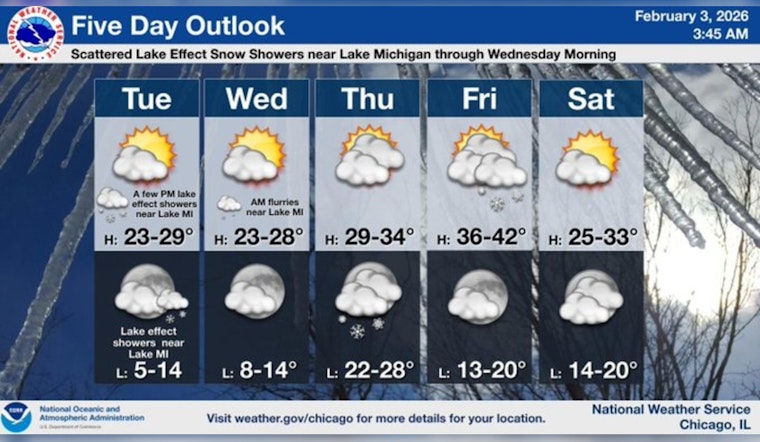
Chicago rolled into Tuesday, February 3, 2026, on the cold and breezy side, with Midway Airport starting the day near 19°F and WNW winds gusting around 25 mph. That bite in the air is not going anywhere fast, with highs only near 28°F before readings slide back into the low 20s this afternoon.
What To Expect Tuesday
Between about 10 a.m. and noon, scattered snow showers are in play, mainly inland, with a high near 28°F before temperatures fall toward 23°F later in the day. The real wildcard is a narrow convective snow band now tracking across portions of LaSalle, Grundy, southern Will and Kankakee counties. It could squeeze out 1 to locally 4 inches of snow in a tight 5 to 10 mile stripe, creating slick roads and brief but intense bursts of heavy snow.
Winds are expected to turn from NNW to N tonight, easing into lighter northwesterly breezes around 5 to 10 mph. A special weather statement is up for the most affected corridors, according to NWS Chicago.
Where To Watch
Roads are the big concern wherever that skinny band decides to park itself. Drivers on I-39, I-55, I-57 and I-80 could run into suddenly reduced visibility and slick pavement over relatively short stretches this morning. If you have to head out, build in some extra travel time and check real-time road conditions before you go. The state’s travel site, Illinois 511, is posting live updates for the key interstates.
On local streets, low-lying and shaded spots may turn slushy, then freeze up again tonight as temperatures dip into the teens, so expect some sneaky icy patches after dark.
Tonight Into Wednesday
Scattered snow showers are expected to pick back up after about 8 p.m., with mostly cloudy skies and a low near 15°F. There is roughly a 40 percent chance of light new snow, with most spots seeing only a dusting to around a half inch at most.
Lake effect snow showers could brush the Chicago lakeshore into Wednesday morning, although inland accumulations should stay under an inch from the city shore eastward toward Ogden Dunes. Wednesday itself looks quieter overall, with highs in the mid 20s as the banding breaks apart and winds continue to ease.
Late Week Outlook
By Thursday, expect mostly cloudy skies and a push toward near-freezing highs around 32°F. A stronger clipper system arriving late Thursday into Friday may kick off spotty snow showers along the lakeshore.
Friday trends milder, with highs moving into the upper 30s. That will mark the start of a brief warming stretch that could keep both daytime highs and overnight lows above freezing by the middle of next week. Precipitation totals through the period are expected to stay on the light side, but brief, localized slick spots on side streets and bridges will remain a recurring nuisance.
Quick Tips
Plan on a slower-than-normal morning commute anywhere that snow band sets up. Give yourself extra time, ease off the gas when you hit heavier squalls and leave plenty of room for snowplows to do their thing.
If your trip is not urgent, consider waiting until later this morning. If you do go out, stash an ice scraper, warm layers and a fully charged phone in the car in case conditions go downhill quickly. Transit riders should keep an eye on local alerts for buses and Metra, since those quick bursts of snow can still cause brief slowdowns and minor delays.


