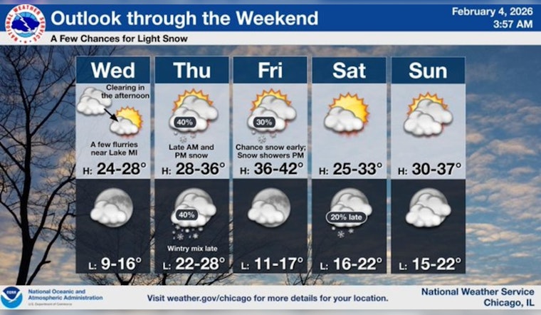
Light snow is drifting across Chicago this morning, with temperatures stuck in the low 20s and untreated sidewalks and side streets turning slick in spots. Most neighborhoods are only seeing quick-hit flurries with little to no accumulation through midday, so think chilly, damp commute rather than full-on winter storm.
What To Expect Today
Isolated snow showers may pop up before noon, with a high near 26°F and only about a 15–20% chance of measurable precipitation, according to the National Weather Service in Chicago. Skies stay mostly cloudy, with a light northwest breeze around 5 mph. Where skies clear out tonight, lows will drop into the teens.
Thursday Into The Weekend
A pair of quick clipper systems will swing through on Thursday and again Thursday night, bringing scattered snow showers but little accumulation, generally under a half-inch for most areas. The snow will be brief and hit-and-miss, though winds could gust up to around 20 mph late Thursday and into the night. By Friday, temperatures are expected to climb above freezing across most of the metro, finally breaking the recent streak of sub-freezing daily highs.
Commute And Practical Tips
Rush-hour issues should be minor, but plan a few extra minutes for slick, untreated surfaces and be ready for brief visibility drops when any heavier flurries move through. City crews are set to tackle any light buildup, and transit agencies typically keep service running smoothly during isolated showers, though it is still smart to check local transit advisories if you are on a tight schedule. For the latest timing and any updates, see the National Weather Service in Chicago.


