Chicago woke up under a clean blue sky Wednesday, with thermometers hovering near 27°F and a stiff west-northwest breeze that made it feel every bit like late winter. The sun should rule the day, but that wind will keep the air feeling crisper than the numbers suggest.
Afternoon Gusts and Lake Safety
This afternoon’s high is expected to top out near 36°F, with west-northwest winds around 10 to 15 mph and gusts that could reach 25 mph. That will leave lakeshore paths, open overpasses and exposed bridges feeling extra blustery.
A Small Craft Advisory remains in effect for nearshore Lake Michigan waters from Winthrop Harbor down to Burns Harbor, so recreational boaters are better off staying in port and making sure loose gear is tied down. Early Wednesday readings from area stations showed temperatures in the upper 20s; you can find the full advisory details and an hour-by-hour breakdown from NWS Chicago.
Warm Friday, Then A Weekend Turn
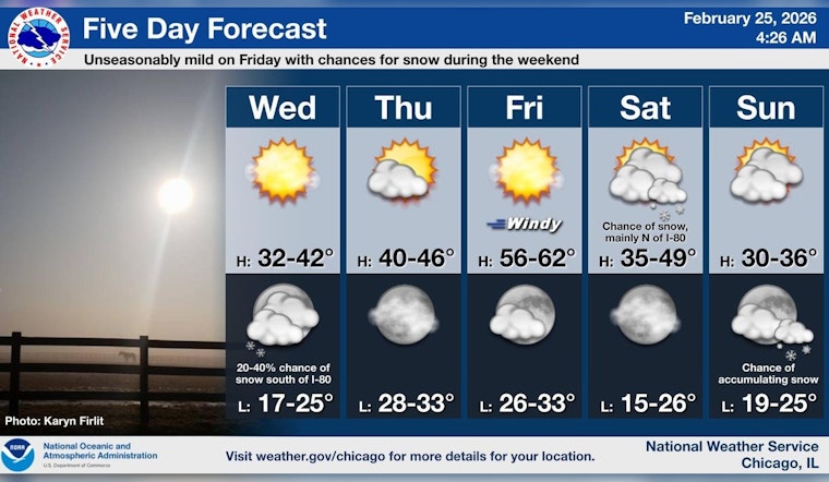
Temperatures bounce back quickly to close out the workweek, with highs expected to reach near 56°F on Friday, February 27, 2026. It should feel like a quick sneak peek of spring before a colder push muscles back in.
Forecast models show a clipper system sliding through on Saturday, February 28, 2026, with the potential for light snow across the northern suburbs and closer to the Wisconsin state line. Most places should see only minor accumulations, according to the Chicago Sun-Times.
If your plans include a lakefront run or a late-week rooftop meetup, it is a good idea to tie down patio furniture and be ready for shifting road conditions as the weekend system moves through. Before heading out, check the latest forecast from NWS Chicago and keep an eye on local transit alerts.


