Tuesday, February 24, 2026 — Chicago woke up to a classic late-winter slap in the face, with cool, blustery conditions and morning readings in the 20s. The high is expected to reach near 41F, but strengthening southerly winds through late morning and into the afternoon will make it feel quite a bit colder than the numbers suggest.
Afternoon Winds Pick Up
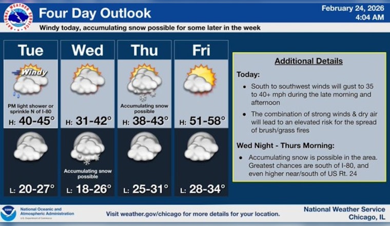
Southerly winds are set to ramp up to 1025 mph, with widespread gusts in the 35240 mph range late this morning into the afternoon. Isolated gusts to 45250 mph are possible along and east of the I055 corridor. Those winds should ease toward sunset as the low-level jet shifts east. According to the National Weather Servicein Chicago, some gusts could briefly reach above 40 mph, so it is a good day to secure loose outdoor items and stay cautious if you are driving a high-profile vehicle.
Spotty Light Rain This Afternoon, Colder Tonight
A few very light showers or sprinkles could pop up this afternoon, mainly after 3 p.m., but any rain that does fall is expected to be brief and on the light side. Tonight turns colder, with a low near 26F before readings edge back toward the upper 20s overnight as winds swing around to the west at 1520 mph, with gusts up to 30 mph. Overall precipitation totals look minimal, with little to no accumulation expected on paved surfaces.
Wednesday Night Snow More Likely South
There is a chance for accumulating snow from Wednesday night into Thursday morning, but the main concern is focused well south of Chicago. Current model guidance favors areas south of I80 for measurable snow, with a narrow corridor in central Illinois potentially seeing 12 inches and localized higher amounts. The National Weather Service in Chicago says confidence in the exact setup is low and advises travelers to keep an eye on updates if they will be on the roads Thursday morning.
Fire Weather And Lake Conditions
Several weeks of dry weather and limited snow cover have left grasses and brush ready to burn, and today’s gusty southerly winds will not help. That combination brings a heightened grass and brush fire risk across northern Illinois this afternoon. While there is no Red Flag Warning in place right now, residents are urged to skip open burning and stay careful with outdoor equipment. Over Lake Michigan, a Gale Warning is in effect for the nearshore waters through 6 p.m., so small craft operators are better off staying in port, and shoreline visitors should be ready for rough waves and blowing spray.
What To Expect And What To Do
Plan on tying down or bringing in lightweight outdoor items, allowing extra time for afternoon and evening travel, and dealing with gusty crosswinds on exposed bridges and lakefront roads. If you were banking on outdoor plans, consider moving them inside or pushing them back until winds ease. Mariners should heed the lake advisory. For the latest conditions and any changes as the day unfolds, check updates from the National Weather Service Chicago before heading out.


