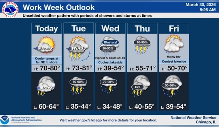
Chicago wakes up under clear skies this morning with temperatures in the low 50s, but it will not stay mild for long. Highs are expected to jump into the mid-to-upper 70s on Monday, March 30, 2026, setting up an unseasonably warm afternoon across the city. That early spring preview will be short-lived, though: late Monday night into Tuesday, scattered showers and thunderstorms move in and are expected to intensify Tuesday afternoon and evening.
Afternoon Winds Pick Up
By this afternoon, look for a high near 76F with south-southwest winds around 10 to 15 mph. Gusts could reach 25 to 30 mph, making it feel noticeably breezier than the air temperature alone would suggest. A few isolated showers are possible after midnight, but the more widespread rain and thunderstorms are expected Tuesday, March 31, 2026. In the stronger storms, wind gusts could reach up to 35 mph, and rainfall totals of roughly a quarter to a half inch are on the table. Some storms could be strong to locally severe with hail and damaging wind gusts, according to the National Weather Service Chicago.
Evening Commute And Safety Tips
If you have plans out and about Tuesday evening, build in some extra travel time. Brief heavy downpours and gusty winds can quickly slow traffic and leave roads slick. Before tonight’s breeze really ramps up, secure patio furniture and any loose yard items that might try to go airborne. Keeping an umbrella or light waterproof layer handy for afternoon activities is a smart move, and it is worth charging phones and having a backup plan for any outdoor events scheduled for Tuesday night.
Transit Alerts And Planning
Riders should check transit updates before heading out; strong winds and storms can cause delays or slowdowns on buses and commuter rail. For those relying on the 'L' or buses Tuesday, you can sign up for real-time notices or check CTA Service Alerts to stay ahead of any weather-related service changes.
Looking Ahead
Once the front moves through, temperatures drop sharply on Wednesday, with highs stuck near 40F and persistent northeast winds keeping things feeling raw. The weather pattern stays active through the rest of the week, with additional systems expected to bring more rounds of showers Thursday and into the weekend. Anyone with outdoor plans later in the week will want to keep an eye on updated forecasts.


