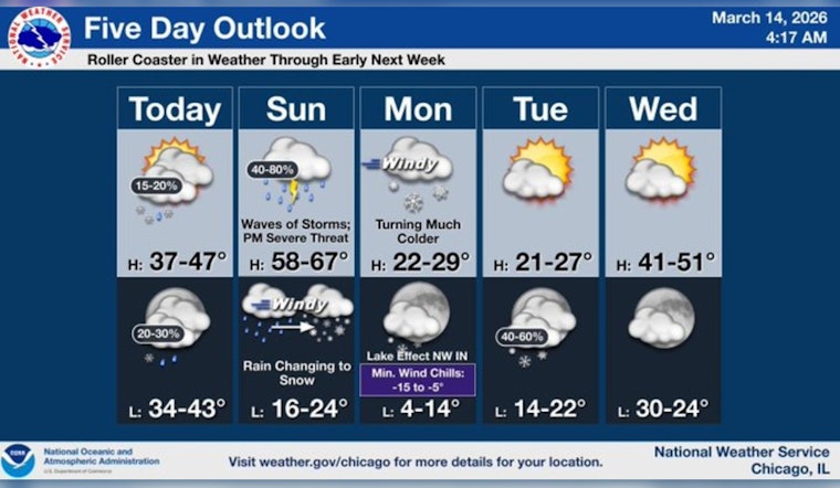
Chicago eased into Saturday under mostly cloudy skies and a morning temperature near 32°F, with only a light northeast breeze. Highs are expected to reach the upper 30s, and any midday snow showers should be minor, more of a lawn dusting than a driving hazard. The quiet start will not last. A surge of warmth, strong winds and thunderstorms is on tap for Sunday, followed by a sharp cool-down and accumulating snow Sunday night into Monday.
Afternoon: Slim Shot At Spotty Flurries
This afternoon, Saturday, March 14, stays mostly cloudy with a slight chance of light snow between about noon and 4 p.m. Temperatures should top out around 38°F, which means most flakes will melt on contact or stick mainly to grass instead of roads. East-northeast winds will run around 5 to 10 mph with occasional gusts near 20 mph, so lakefront paths and open areas will feel noticeably breezy.
Sunday Into Monday: Spring Tease, Howling Winds And Back-To-Back Snow
The real action arrives Sunday, March 15. Temperatures are forecast to jump into the low 60s with south winds of 15 to 25 mph and gusts up to about 40 mph. Showers and thunderstorms are likely during the day and into the evening. Forecasters highlight a risk for damaging wind with some storms, particularly east of I-55, and a narrow squall line could march across the area around the evening commute.
Late Sunday night into Monday, March 16, colder air moves in and rain changes to snow. The National Weather Service has issued a Winter Storm Watch for parts of northwest Illinois, where 1 to 3 inches of snow and strong northwest gusts are possible. For the latest watches and advisories, see the National Weather Service.
Commute And Lakefront Impacts
Drivers should be ready for late-day slowdowns on Sunday as strong gusts and downed branches may affect roads and cause isolated power outages. By Monday morning, the commute could feature blowing snow and slick patches, especially in areas that pick up more accumulation.
On Lake Michigan, boaters and anyone planning time on or near the water should note that a Gale Watch and Small Craft Advisory are in effect for the nearshore waters, with rough conditions and poor visibility expected. Transit riders should keep an eye on service alerts and be prepared for slower buses where roads turn slick. Before you head out, check the CTA for updates.
Quick Tips
If you have outdoor plans Sunday afternoon or evening, consider moving them inside or rescheduling, and secure loose patio furniture or decorations ahead of the strongest winds. If you must travel Monday morning, build in extra time, avoid driving high-profile vehicles on exposed stretches, and be prepared for whiteout or near-whiteout conditions northwest of I-55. Keep phones charged, follow updates from the National Weather Service, and factor in weather delays for any weekend events.


