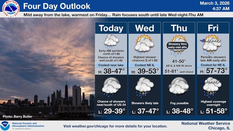
Chicago is waking up under a thick blanket of gray this morning, Tuesday, March 3, 2026, with temperatures stuck in the mid-30s near downtown. A few isolated rain showers could sneak through before 7 a.m., but for most of the city, the day looks mainly dry and mostly cloudy, with a high near 39°F and a light east breeze off Lake Michigan.
What To Expect Today
Early on, spotty showers are the main nuisance, and many neighborhoods will miss them entirely. As the day wears on, inland spots should inch into the upper 30s to low 40s while the lakefront hangs a few degrees cooler. Winds from the east at 5 to 10 mph will keep things chilly but should not cause major travel headaches this afternoon.
The National Weather Service is keeping rain chances low today, although the overall pattern turns wetter later in the week. See the latest forecast from NWS Chicago for updated timing and any watches or advisories.
Tonight And Wednesday
Clouds stick around tonight with a low near 35°F and a northeast wind at 5 to 10 mph. Patchy fog or mist could form overnight into Wednesday morning, especially in inland suburbs where skies may briefly thin out. Any thicker fog could cut visibility enough to slow the Wednesday morning commute.
Wednesday itself looks mostly cloudy with a high of around 40°F. There is only a slight chance of afternoon sprinkles before shower chances start to ramp up again after dark.
Late-Week Warm-Up And Storms
Showers are likely to expand late Wednesday night into Thursday, with periods of steadier rain and a few heavier downpours possible. Inland highs on Thursday should reach the low 40s.
The National Weather Service is signaling higher rain probabilities Thursday and again from Friday into Saturday as a warm front lifts north. That setup could support scattered thunderstorms and localized heavy rainfall, and many inland neighborhoods may surge into the 60s on Friday. For more background on the evolving pattern, see our earlier update on the weather whiplash week ahead.
Commute And What To Pack
Build in a little extra time for the Wednesday morning drive in case patchy fog develops, and be ready for wet roads late Wednesday night into Thursday as showers fill in. An umbrella will come in handy through the middle of the week. If you have outdoor plans from Friday night into Saturday morning, keep a close eye on the forecast, since the warm surge boosts both temperatures and the odds of thunderstorms.


