Chicago rolled into Sunday, March 15, 2026, with a mild but choppy start. Morning temperatures sat in the upper 30s to low 40s and are expected to climb into the upper 50s this afternoon. The tradeoff for the relative warmth is a stiff southerly breeze that ramps up through the day, followed by scattered showers and thunderstorms. By tonight the same system flips the script to much colder air, bringing a wintry mix that could briefly coat surfaces before Monday’s cold air settles in for good.
Afternoon Winds Pick Up
A Wind Advisory is in effect Sunday from late morning through about 9 p.m. CDT for much of the Chicago metro area. South-southeast winds will run 15 to 30 mph with frequent gusts of 45 to 50 mph, and isolated higher gusts are possible in parts of the region. A narrow band of storms this evening could drag down damaging gusts well above advisory levels, and the strongest winds will be most hazardous on bridges and elevated roadways. Residents are urged to secure loose outdoor items and be ready for sudden wind shifts, according to NWS Chicago.
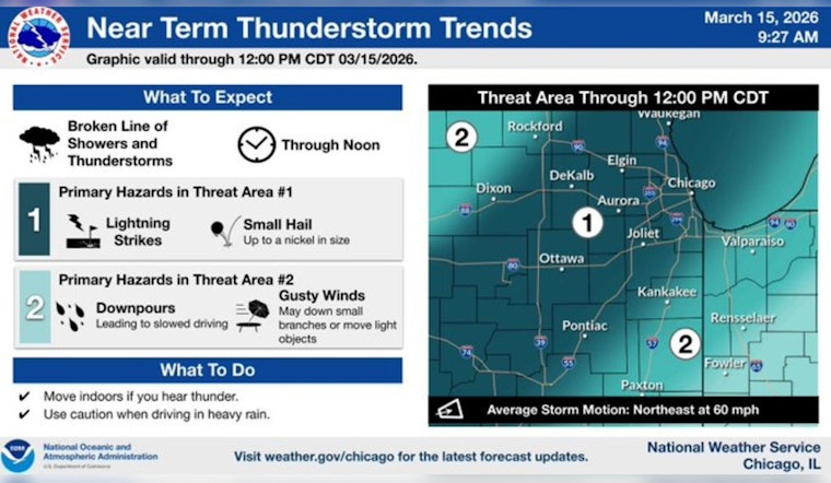
Showers, Thunderstorms Then Snow
Showers and scattered thunderstorms are on the table from late morning through the evening, with the best shot at more organized storms in the late afternoon and early evening. Any storms that do develop may bring brief heavy downpours along with strong outflow winds. Late Sunday night into Monday morning, rain is expected to flip to a mix and then to snow. Most spots should see new snow amounts generally under an inch overnight, although pockets of 1 to 3 inches are possible Monday where winds pile the snow and make travel difficult. Monday turns sharply colder, with highs near the mid 20s and wind chills dipping below zero in some locations.
What This Means For Your Commute
Travel is likely to slow down this afternoon and evening, as high-profile vehicles will be especially vulnerable in stronger gusts and road crews may be out treating bridges and ramps once temperatures begin to fall. Securing patio furniture and any other loose items this morning is a smart move, and drivers who must be on the road later today should build in extra time. For background on how this warm-to-cold pattern set up earlier this week, see our previous coverage on springlike warmth blowing in.
When To Check Back
Conditions could change quickly if the convective band of storms develops or tracks differently than forecast, so it is worth keeping an eye on updates through Sunday evening. If you have outdoor plans Monday, prepare for gusty winds, bitter cold, and brief bursts of heavy snow. Plan for delays, layer up, and treat it like a midwinter day even if the calendar says otherwise.


