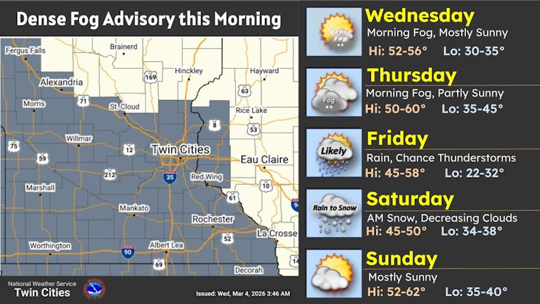
Dense fog swallowed up Minneapolis early Wednesday, March 4, 2026, chopping visibility down to about a quarter mile or less and turning the morning commute into a slow, low-visibility crawl in many low-lying neighborhoods. A Dense Fog Advisory is in effect for much of the Twin Cities through 10 a.m. CST, with sunshine expected to break through by mid-morning and push highs to near 55°F. Patchy fog is likely to redevelop tonight into Thursday morning, so early drivers should brace for another sluggish start.
How The Day Shapes Up
According to the National Weather Service Twin Cities, the thick fog should start thinning between 9 and 10 a.m., with light south winds around 5 mph and mostly sunny skies taking over this afternoon. The office's Area Forecast Discussion adds that much-above-normal warmth is expected to hold on into early next week, keeping afternoons mild through Monday.
Friday Storm Watch
Forecasters are tracking a stronger system for Friday that looks set to bring widespread rain and a chance of evening thunderstorms across southern and central Minnesota. In the Twin Cities, rain totals of roughly a quarter to a half inch are on the table, with temperatures dropping Friday night and a quick flip to rain and snow showers. Where the cooling happens fastest, a light dusting to around a half inch of slushy accumulation is possible.
Commute And Safety
Drivers are urged to slow down, stick with low-beam headlights, and leave extra room to stop, in line with the advisory’s specific recommendations. At MSP, expect low IFR to LIFR conditions this morning before a gradual improvement to MVFR and then VFR after sunrise. Give yourself extra time for airport runs and check with your airline for any schedule changes before heading out.
Outlook
After the quick burst of wet, unsettled weather from Friday into early Saturday, conditions turn drier and cooler Saturday, with highs near the upper 40s. A fast warm-up follows Sunday into Monday, when temperatures are projected to climb into the 60s. If you have plans Friday evening or early travel Saturday morning, keep an eye on forecast updates.


